Explore Andalucía
The longest hike in Spain is in Malaga and is more than 900 kilometres long
This impressive route involves wooden footbridges over the sea, suspension bridges over cliffs and rivers, vineyards, white villages and mountains, and offers spectacular views

María Alonso
Malaga
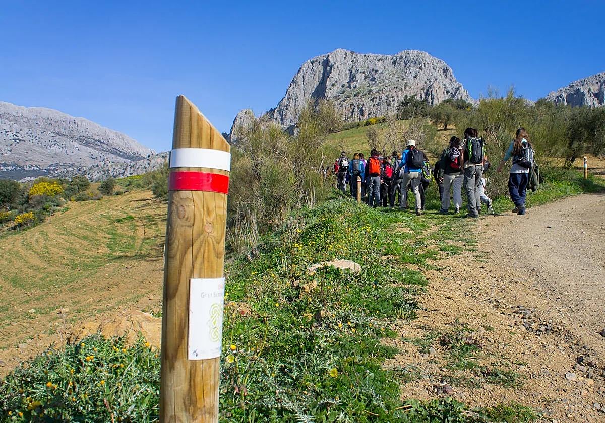
The Gran Senda de Malaga (Great Trail of Malaga) makes it possible to discover the province, crossing wooden footbridges over the sea, high suspension bridges, vineyards, white villages and mountains
With 35 stages and six variants, 942 kilometres, nine zones, 54 town centres (more than half of which - 35 - are villages with fewer than 20,000 inhabitants) and 61 municipalities, this route allows hiking enthusiasts to get to know every corner of Malaga province and immerse themselves in its culture and traditions.
The route has also been approved by the Andalusian mountain federation as a long-distance hike (GR), so it is perfectly signposted along the way.
Activities
The Gran Senda de Malaga crosses 13 protected natural areas. It can be travelled on by foot, bicycle or on horseback, along paths, tracks and trails, through river basins and lagoons, plains, mountain areas and the coast, allowing visitors to discover and enjoy the essence of Malaga province.
In addition to hiking, there are other sporting activities available along the route, such as rafting, rock climbing, canoeing, gliding, mountain biking and canyoning.
You can also do 'geocaching', a game that could be described as "geographically capture or catch". It is a kind of scavenger hunt in which you have to use a GPS receiver to search for 'treasures' that another participant in the game has hidden somewhere. It is, therefore, a fun way to explore natural areas and to be in contact with other people with similar interests.
Along the impressive route, there are numerous bathing areas, such as the Pozas del río Sábar, the source of the river Salado (Almargen), the Charco del Infierno (Almogía), the Cascada de Jorox (Alozaina), the Charco de la Caldera de Río Grande (Alozaina), the Charco de las Mozas of the river Guadalmina, the Charco de la Barranca of the river Guadiaro (Benaoján), Charco Frío of the river Gaduares (Benaoján) or the Charco de la Escribana of the river Genal (Benarrabá).
Nature and heritage
The trail is ideal for nature lovers. Along its more than 900 kilometres you can walk through four natural parks (Sierra Tejeda, Almijara and Alhama, Sierra de las Nieves - soon to be a national park - , Alcornocales and Sierra de Grazalema), two nature reserves (Laguna de Fuente de Piedra and Lagunas de Campillos) and five nature reserves (Desfiladero de los Gaitanes, Sierra de Crestellina, Los Reales de Sierra Bermeja, Desembocadura del Guadalhorce and Torcal de Antequera).
But beyond the impressive natural landscapes through which the Gran Senda passes, travelling along it is also a journey through the cultures of Malaga province, through its historical heritage, its traditions, its idiosyncrasies and the daily life of its people.
The route passes through thousands of points of tourist interest thanks to a rich historical heritage (museums, monuments, archaeological sites, among others), fabulous nature, ancient traditions,... and an exceptional tourist offer such as hotels, rural houses, restaurants, spas, wineries, viewpoints, marinas, golf courses and tourist offices.
Specifically, you can see, for example, the fortress and medina of Bobastro, the Palaeolithic art of Cueva de Ardales, the site of Castillón de Gobantes or the industrial heritage of the 19th and 20th centuries, including sugar mills and large reservoirs. There are also agricultural landscapes with farmhouses, cultivated fields and authentic seas of olive trees. And a must, too, are white villages such as Frigiliana, Monda, Alameda, Carratraca, Benaoján or Villanueva del Rosario, and the bodegas, ventas and restaurants where you can enjoy the wines and typical dishes of Malaga province.
Tour
The description of the stages adopts a certain direction of travel, which in this case is counter-clockwise, so the route leaves Malaga city, where Waypoint Zero is located, to the west, towards the eastern Costa del Sol.
The 35 stages and six variants comprise of more than 900 kilometres in a route where other paths complement and add to, so that the GR 249 becomes the backbone ring that now unites them all.
The Gran Senda de Malaga runs westwards along the four stages of the eastern Costa del Sol, leaving the coast at Nerja and turning north-eastwards along four more stages through the Sierras de Tejeda, Almijara and Alhama. It is followed from Periana by three stages in a general northerly direction, crossing the central limestone arch and finishing in Villanueva del Rosario. The journey through the north-eastern region of Malaga reaches Alameda with five different routes and one variant, progressively turning north to east.
In the region of Antequera, from Alameda to Campillos there are three routes and a variant through the countryside and the northern lagoons of Malaga. The Paraje Natural del Desfiladero de los Gaitanes warrants at least two days, while the next two in the Sierra de las Nieves are designed to reach Ronda following the line marked by the River Turón and its tributaries. Two new variants have been added here, the fifth, linking Campillos with Ronda and the sixth linking Ronda with Montejaque, Cortes de la Frontera and Genalguacil and Benarrabá.
Continuing the journey to the southwest, the region of the Serranía de Ronda is divided into three stages through the Guadiaro Valley and two more through the Genal valley, towards the south, with the hinge town of Benalauría and reaching Casares. The western Costa del Sol is covered by the last seven stages.