Weather
Emergency military unit troops deployed in north of Spain due to 'Dana' and heavy rain of last few hours
A total of 25 provinces across the country are under alert today for downpours and storms, eight of them at an amber level
Europa Press
Malaga
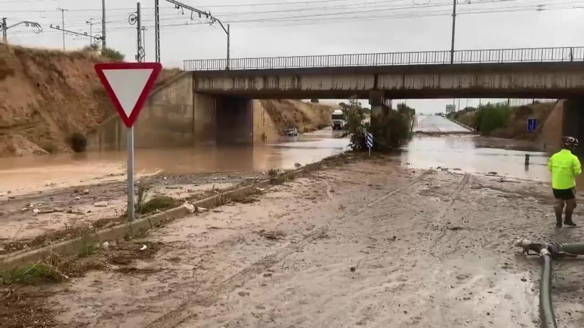
A total of 25 provinces across Spain will be under heavy rain and storm warnings this Saturday, eight of them at amber level, according to the forecast of the state meteorological agency (Aemet). Some damage has already been caused in Aragon, where the UME military emergency unit has been deployed as a result of heavy rains in recent hours and the closure of some of the roads in the region, which this Saturday remains in amber warning until 9pm. Specifically, the road cut off by flooding is the A-122 in both directions at Pedrola and Figueruelas. In addition, during the night there were blackouts in municipalities such as Pradilla de Ebro and Boquiñeni, both in the province of Zaragoza, due to a fault in the medium-voltage electrical installation, until the electricity supply was restored at 4 am.
#Inundaciones #RiberaDelEbro
— UME (@UMEgob) July 12, 2025
Los equipos de la #UME desplegados en las localidades afectadas, continuan con las misiones asignadas de achique y bombeo con maquinaria. @Defensagob@DelGobEnAragon@GobAragon@112Aragon pic.twitter.com/oDbbk8mBpw
In view of this situation, the integrated operational coordination centre (Cecopi) of the regional government in Aragon is analysing the situation caused by the 'Dana' weather depression that has affected this region, which, after the red warning was activated by Aemet at 11pm on Friday, activated the S-Alert alert system, warning the population of the affected areas. The warning was deactivated at around 2am and, according to the Aragonese Minister of the Interior, Roberto Bermúdez, it served as a good method of "prevention", reducing the risks.
Even so, throughout the night there have been some thirty incidents in Aragon related to flooding in premises and falling trees, which have mainly affected the centre of Tarazona, where 60mm of rain fell and where several garages, basements and sports centres suffered damage. In Grisen, a village in the Ribera Alta del Ebro, last night's rain forced several rescues of people trapped by water, according to MeteoAragón. In particular, in an old people's home there were tense moments due to the hailstorm that occurred late in the evening.
Situación muy complicada en estos momentos en Grisen (Zaragoza). Según algunas informaciones, hay personas atrapadas en algunos bajos de sus casas y en sus vehículos... Los servicios de emergencias han realizado hasta el momento ocho rescates.
— Meteo Aragón (@meteo_aragon) July 11, 2025
Vídeo vía @alexfeijoo2. pic.twitter.com/RrJbk73nCG
Specifically today, Aemet has activated amber level risk alerts for heavy rain and storms in Huesca, Teruel and Zaragoza (Aragon), Barcelona, Girona, Lleida and Tarragona (Catalonia) and Castellón (Valencia). Right now, the Government of Aragon is warning of possible storms in the Pyrenees, where they have dozens of camps with children, so security protocols have been activated, but without having to evacuate them yet. Likewise, in Teruel and Alcañiz, heavy storms are expected.
#Inundaciones #RiberaDelEbro
— UME (@UMEgob) July 12, 2025
Los equipos de la #UME desplegados en las localidades afectadas, continuan con las misiones asignadas de achique y bombeo con maquinaria. @Defensagob@DelGobEnAragon@GobAragon@112Aragon pic.twitter.com/oDbbk8mBpw
There will also be warnings for rain and thunderstorms in Alicante and Valencia (Valencia region), Ribera del Ebro de La Rioja and Ibérica Riojana (La Rioja), Álava, Guipúzcoa and Bizkaia (País Vasco), Centro de Navarra, Pirineo Navarro and Ribera del Ebro de Navarra (Navarra region) and in Burgos, Palencia, Segovia and Soria (Castilla y León).
There will also be storm warnings in Mallorca and Menorca (Balearic Islands), Valladolid (Castile and Leon), as well as heat warnings in Alicante (Valencia) and coastal phenomena in Almeria, Granada and Malaga (Andalucía).
Aemet forecasts for this Saturday that the 'Dana' depression that penetrated the northwest of the Spanish mainland on Friday will continue to move eastwards, causing a situation of instability with cloudy or overcast skies and showers with thunderstorms in the northern half and far east of the country, especially affecting the northeastern quadrant.
As a result, from the early hours of Saturday onwards these showers and storms will affect the north-eastern quadrant, where they are likely to be strong and persistent in large areas and occasionally accompanied by hail. It will be possible to reach very heavy, even locally torrential, intensities in regions of Catalonia, Aragon and Valencia.
Likewise, in the afternoon, a cloudiness of evolution will develop, causing downpours and thunderstorms to spread to the Cantabrian area, the northern plateau, other regions of the far east of the Spanish mainland and the Balearic Islands, with the possibility of heavy showers in these areas. By the end of the day, a general tendency towards stabilisation is expected, with more and more clearings opening up.
According to the Aemet forecast, in the rest of the country more stable weather is expected, with little cloudy or clear skies and abundant low cloudiness in the morning in the south of the Atlantic slope. In the Canary Islands, cloudy or partly cloudy skies in the north of the islands and partly cloudy in the rest.
Temperatures will remain stable in the Balearic Islands and will fall in the Canary Islands and on the Spanish mainland, notably in the north-east, and except for increases in the highs in the extreme west and south-east of the country. Inland temperatures are expected to exceed 36C in the extreme southeast.
Finally, light winds are forecast over the Spanish mainland, with a predominance of southerly and easterly winds in the north-eastern third and on the eastern coast, and westerly winds in the rest of the country. It will be more intense, with strong intervals, in the west in Alborán. Moderate southerly winds will blow in the Balearic Islands and the trade wind will blow with strong intervals and possible very strong gusts in the Canary Islands.