Weather
Aemet warns of unstable weather, heavy rain and a dramatic temperature change in Spain
The arrival of a new Atlantic front will see the thermometers drop by up to 10C, and bring downpours to a large part of the country

Madrid
The autumnal weather has already arrived in Spain and, after several days of quite warm weather, the temperatures that are more typical of this season will begin to be felt over the next few days. According to the state meteorological agency (Aemet), the week ahead will bring a somewhat cooler atmosphere in many parts of the country, as well as heavy rainfall in parts of the far north of the mainland and the Spanish Levante.
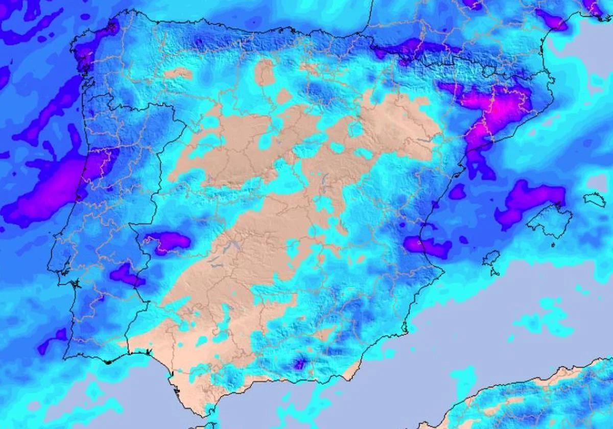
Since this Sunday, the advance of an Atlantic front over Galicia has been leaving cloudy skies and some precipitation accompanied by thunderstorms in the northwest of the peninsula. The situation will become even more unstable from Monday 8 September onwards, leaving showers in the northern third and high clouds in most of the Spanish mainland.
¿Cuál es el tiempo más probable para el resto de septiembre?
— AEMET (@AEMET_Esp) September 5, 2025
➡️La próxima semana, lluvias en zonas del norte peninsular y Baleares. Ambiente fresco en el oeste y cálido en el Mediterráneo.
➡️La segunda quincena podría ser más cálida y seca de lo normal.https://t.co/LrIkgfbWlg
Along with these rains, there will also be a sharp drop in temperatures, which will continue to fall throughout next week. Some regions will record highs close to 20C, although the heat will not disappear throughout Spain: in the southeast of Spain, temperatures could reach around 35C on Monday.
An Atlantic front will bring rain to Spain over the next few hours
The passage of an Atlantic front will set the mood for the coming week. According to the Aemet forecast for this week, from 8 to 14 September, it is expected to be a week of heavy rainfall and above normal for the season, especially «in Galicia, the far north of the mainland, Catalonia and the Balearic Islands».
The instability will increase this Monday with this storm, which will advance from Galicia to reach a good part of the northern third, leaving in its path abundant rainfall and cloudy skies in a good part of the country. These showers will stay far away from southern Spain, although we could see some showers in the eastern half as the days go by.
Una vaguada se acerca a la península. 〰️ Es esa 'U' que trazan las flechas, que representan el viento a unos 10 km de altitud.
— Meteored | tiempo.com (@MeteoredES) September 6, 2025
La zona delantera ⤴️ será la 'lanzadera' de las tormentas del lunes-martes.
ℹ️ https://t.co/Dx9Hos8OAy pic.twitter.com/xReTSe7ERz
According to Rubén del Campo, spokesperson for Aemet, the «most likely and abundant» rainfall will be seen in Galicia, around the Cantabrian Sea and the Pyrenees. Even so, Aemet does not rule out the possibility of «stormy showers in the north-east, especially in Catalonia and the north of the Valencia region, which could be locally heavy«.
On Tuesday, instability will continue to increase, especially in the Mediterranean area. There will be locally heavy showers in Catalonia, as well as in the north of Valencia. It could also reach the Balearic Islands in the course of the day.
Even so, rainfall will not reach all parts of Spain, but will be limited to the north and east of the country. In addition, it is most likely that rainfall «will be scarce in the southwest of the mainland».
Una vaguada se acerca a la península. 〰️ Es esa 'U' que trazan las flechas, que representan el viento a unos 10 km de altitud.
— Meteored | tiempo.com (@MeteoredES) September 6, 2025
La zona delantera ⤴️ será la 'lanzadera' de las tormentas del lunes-martes.
ℹ️ https://t.co/Dx9Hos8OAy pic.twitter.com/xReTSe7ERz
It will be on Wednesday when this unstable atmosphere will stabilise again, with showers that will disappear from almost the entire country. Even so, showers will continue for a few days in the northern third of the mainland, although accumulations will decrease compared to previous days.
A week of thermal contrasts between north and south
As for temperatures, Aemet points out that they are expected to be «below normal for the time of year in the west of the country«. It is expected that in parts of the Cantabrian and northwest areas thermometers will be around 20C maximum throughout the day on Monday, almost 10 degrees less than in previous days.
This will not be the case in the Mediterranean area, where these values could be above the usual for this meteorological start of autumn. In the southeastern provinces, such as Murcia and Alicante, temperatures at the beginning of the week could be around 35C.