Weather
Aemet warns of another weather change after torrential rains in Spain: high temperatures will return to these areas
After the passage of this Atlantic trough, the summer-like heat will be back, although the risk of more rainfall remains in many parts

Madrid
After several days of weather instability in Spain, the torrential rains that devastated the eastern third of the Spanish mainland and the Balearic islands are over. According to the state meteorological agency (Aemet), the Atlantic trough that caused the very heavy downpours and flooding since lMonday will begin to move away this Wednesday 10 September, giving way to the arrival of an anticyclone.
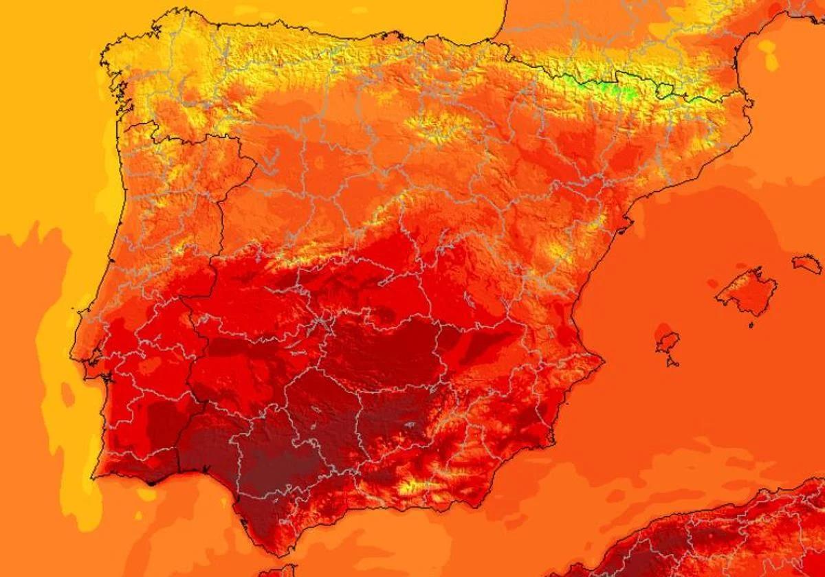
This abrupt change in the weather will also affect the temperatures, which dropped at the beginning of the week to somewhat cooler than usual for this time of year. Now, with the stable environment expected at the end of the week, a new rise in the thermometers will also arrive, which will once again bring warmth to many regions of the country. From Thursday onwards, many regions of the Spanish mainland could once again reach over 35C.
Even so, rain will continue this Wednesday, especially in the far eastern parts of the mainland and Balearic Islands. The heaviest will be seen in the archipelago, where «very heavy» rain is expected, with locally torrential downpours not ruled out. In addition, the passage of a new Atlantic front from the west will complicate the situation in Galicia and the Cantabrian Sea in the coming hours.
Torrential rains are over, but instability will continue in Spain
After the brief passage of this Atlantic trough , which left some flooding on Monday and Tuesday in parts of Catalonia, Valencia and the Balearic Islands, the torrential rains of these days will begin to disperse from Wednesday 10 September. Even so, showers will continue throughout the day in many areas of Spain.
The front will continue to leave rain this Wednesday, especially affecting the «far eastern parts of the mainland and the Balearic Islands«, according to Aemet. The worst will be in the archipelago, where there will be »locally strong showers and storms, very strong or persistent, without ruling out locally torrential intensities«. These could also reach Catalonia and Levante in a weaker form.
A new Atlantic front will move in from the west this Wednesday, leaving cloudy skies over the northwest half of the Spanish mainland and will dump rainfall «in Galicia, the Cantabrian Sea and surrounding areas». Some isolated showers are not ruled out in the northern plateau, northeast Catalonia and the Balearic Islands, as well as in the Ampurdán and Mallorca. In the south of Spain, there will be little cloudiness for the next few hours.
On Thursday the instability will disappear in the Levante and Balearic Islands areas, although it will remain in Galicia and in the western Cantabrian due to the passage of this new storm. According to the Aemet forecast, «heavy and persistent rainfall« will be accompanied by cloudy skies throughout the day.
In the rest of Spain, the anticyclone is expected to start to prevail again, leaving little cloudy skies in the south and east. Even so, some weak precipitation is not ruled out in the Central and Iberian Systems. Nor in the Canary Islands, where we will have cloudy intervals and precipitation in mountain areas of the islands.
Sharp change in temperatures: intense heat returns to these parts of Spain
After the drop in temperatures that has started this second week of September, the intense heat will once again prevail on the Spanish mainland. The anticyclone arriving in Spain will allow highs to rise again in the north, east and south of the country in the coming hours, bringing back almost summer-like weather.
According to Aemet meteorologists, it will be a much warmer environment which will also continue over the weekend. Therefore, from Thursday and especially on Friday, 32-34C could be exceeded in central and southern areas and even 36 degrees in the Guadalquivir valley.
This increase will also be noticeable in the minimum temperatures, which will rise considerably in the west and will not drop below 20C in the Mediterranean. Even so, the first frosts in the Pyrenees are not ruled out.