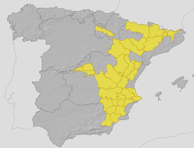
Summer heat continues in Malaga and along Costa del Sol while 16 other provinces in Spain have yellow warnings for rain
The Antequera area will likely record the highest temperature in the province today with 35C, according to state weather agency Aemet
The summer heat continues in Malaga and along the Costa del Sol. Today (Thursday 22 August) the mercury will not drop below 30C during the day, neither in the city nor in the province, according to the forecast of Spain's state weather agency (Aemet). The highest temperatures are expected in the Antequera area, which will reach 35 degrees, while the maximum in Malaga city will be 31C (and the minimum 24 degrees). In the rest of the province, the mercury will range between 30 and 35C.
In Malaga province today, Aemet forecasts a little cloud or clear skies, except for intervals in the morning of low clouds on the coast and in the inland mountain ranges. Minimum temperatures will drop and maximum temperatures will rise inland, while in the coastal areas they will remain unchanged. Winds will blow lightly variable, with breezes, tending towards the end to moderate westerlies on the extreme western coast.
The situation in Malaga contrasts with that which will be recorded in much of Spain, where there will be 16 provinces under a warning for rain, storms and waves. According to Europa Press, there will be warnings for rain and storms in Teruel (Aragon); Albacete and Cuenca (Castilla-La Mancha); Barcelona and Girona (Catalonia); Altiplano and Northwest Murcia and Vega del Segura (Region of Murcia); and Alicante, Castellón and Valencia (Valencia). In Andalucía, only Almeria province will be under a weather warning, which will remain in force from midday to midnight in the Almanzora Valley and Los Vélez-Almería, for rain and thunderstorms.

Zoom

Aemet forecasts stable weather in most of the country with low clouds or high clouds. By areas, only low morning cloud intervals are expected in the Strait of Gibraltar, Melilla, Majorca, the coast of Catalonia, Galicia and the Cantabrian Sea, with probable fog banks. In the west and north of Galicia and inland western Cantabrian Sea, cloudiness will continue and there will be the possibility of occasional light rainfall.
In the afternoon, Aemet expects abundant clouds to evolve in the centre and southeast half of the Spanish mainland. As a result, there will be the possibility of showers and thunderstorms, which will be more likely in mountain areas and surrounding areas and more intense in the eastern Pyrenees, eastern and southern Iberia, eastern La Mancha, inland Levante and northern Murcia, where they can also be locally strong and with hail. In the Canary Islands, there will be intervals of low clouds in the north and in the archipelago and Melilla, a possible weak haze.
With regard to temperatures, the forecast predicts that maximum temperatures will tend to increase in the north-eastern half and the Balearic Islands and that they will do so notably in the upper Ebro. In fact, temperatures may exceed 36C in the depressions of the east and the southern Atlantic slope, as well as in the south of the Canary Islands. In the western third, there will be decreases, which will be notable in the Rías Baixas. Likewise, minimum temperatures will increase in the northern half of the interior, decreasing in the southwest.
The provincial cities with the highest temperatures will be Badajoz, Cordoba, Murcia, Toledo and Zaragoza, whose thermometers will reach 37C; Cáceres, Granada, Guadalajara, Huesca, Lleida, Logroño, Madrid, Seville and Zamora, which will reach 36 degrees; and Albacete, Ciudad Real, Cuenca, Palencia, Salamanca and Valladolid, which will reach 35C. In fact, heat warnings will be in effect for Huesca and Zaragoza (Aragon); Lleida (Catalonia); Metropolitana and Henares and Sur, Vegas and Oeste (Community of Madrid); Ribera del Ebro (La Rioja); Valencia (Community of Valencia) and Gran Canaria (Canary Islands). There will also be warnings for coastal phenomena in Gran Canaria and Tenerife (Canary Islands).
At the same time, a strong trade wind will blow in the Canary Islands with strong intervals in exposed areas. On the Spanish mainland and in the Balearic Islands, light winds will prevail, more intense on the coasts, with south and east components in the Mediterranean area. In addition, it will turn westerly in the Strait of Gibraltar and the Alboran Sea, and will blow westerly on the Atlantic coast, with variable winds in the rest of the area.

