Weather
Storms lessen across Andalucía: these areas still face heavy rain and wind
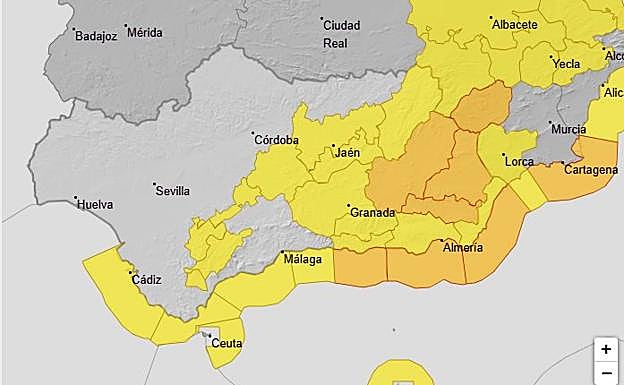
Seven of Andalucía's eight provinces remain under weather warnings this Thursday for rain, wind and coastal phenomena


Malaga
The latest storm, Kristin, left a trail of damage and disruption across Andalucía, but is beginning to subside. However, according to the forecast from Spain's state meteorological agency (Aemet), "locally heavy" rainfall is still expected in the region, plus very strong gusts of wind in eastern Andalucía today. Weather warnings are in effect for rain, maximum gusts of up to 100 km per hour and coastal phenomena across much of the region.
According to Aemet's latest weather forecast, all Andalusian provinces except Huelva will be under weather warnings today. The orange alert for wind remains in effect for Almeria and Granada: specifically Guadix and Baza, Valle del Almanzora and Los Vélez, Nacimiento and Campo de Tabernas. Meanwhile, an orange alert for coastal phenomena is in place along the Granada and Almeria coastlines, due to west and southwest winds of 60 to 70 km per hour (force 8) and waves of four to five metres high.
In Cadiz, a yellow alert is in effect for Grazalema, the coast and the Strait of Gibraltar for rain, wind and coastal conditions. The Subbética area of Cordoba and Seville's Sierra Sur is also on alert for wind with maximum gusts of 70 km/h, while in Jaen, the yellow warning affects Cazorla and Segura, the Guadalquivir Valley, as well as the city of Jaen and surrounding mountains. Lastly, in Malaga, weather warnings remain active for Ronda, due to an accumulated rainfall in 12 hours of 40mm. The same goes for the Sol, Guadalhorce and Axarquia areas, given the forecast of coastal phenomena: westerly winds of 50 to 60 km/h and waves of two to three metres are expected.
Persistent rainfall
Thus, for this Thursday 29 January, very cloudy or overcast skies are forecast with widespread moderate rainfall, which will be locally heavy and persistent, more intense in the Betic mountain ranges, and lighter and less likely in the far east. Aemet reports an intense, humid flow from the west "that will generate locally heavy rainfall" as well as "locally very strong gusts in eastern Andalucía". As for temperatures, minimum temperatures are expected to rise generally, locally significantly, and maximum temperatures are expected to rise on the Mediterranean coast, with little change elsewhere. "Winds will be westerly, moderate inland and moderate to strong along the coast and at higher altitudes, with occasionally very strong gusts."
Looking ahead to Friday 30 January , the weather advisories will remain active in three provinces: Granada, Jaen and Almeria, where an orange alert level (significant risk) will be maintained for maximum gusts of 90 km/h. Spain's national weather agency also expects partly cloudy skies, with high clouds along the Mediterranean coast and predominantly low clouds on the Atlantic coast, "where light rain is possible, more likely and heavier in the Betic Cordillera mountain range". Minimum temperatures will drop, while maximum temperatures will remain unchanged or decrease. Finally, Aemet highlights westerly winds, light to moderate inland and moderate along the coast, with strong to very strong gusts in the eastern third of Andalucía.