Weather
What will the weather be like in Spain this week? These are the areas where rain and storms are forecast
Heavy rainfall is expected in several regions, which could be accompanied by 'calima' sand dust from the Sahara desert in the atmosphere
SUR
Malaga
Wth the official start of summer on its way, the weather in many parts of Spain is still in turmoil. As experts from the Meteored portal point out, the the forecast this week will be influenced by two very important pieces on the atmospheric chessboard: an African subtropical ridge and the nearby presence of a 'Dana', a weather depression in the high levels of the atmosphere.
"On Monday, this 'cold drop' will break away from the general circulation. The cold core will move down parallel to the coast of Portugal with the frontal zone (the most active in upward air movements), affecting the Peninsula. The influence of the low pressure at high altitude could extend at least until Friday, with showers and very strong thunderstorms," warned meteorologist Duncan Wingen from Meteored.
According to the forecast, an anticyclonic ridge will dominate the east of the Spanish mainland and the Balearic Islands, reinforced in the middle levels of the troposphere. As a result, temperatures will be high and the atmosphere will be dusty due to southerly winds. Dust in suspension and medium cloudiness will lead to an increase in tropical nights on the shores of the Mediterranean.
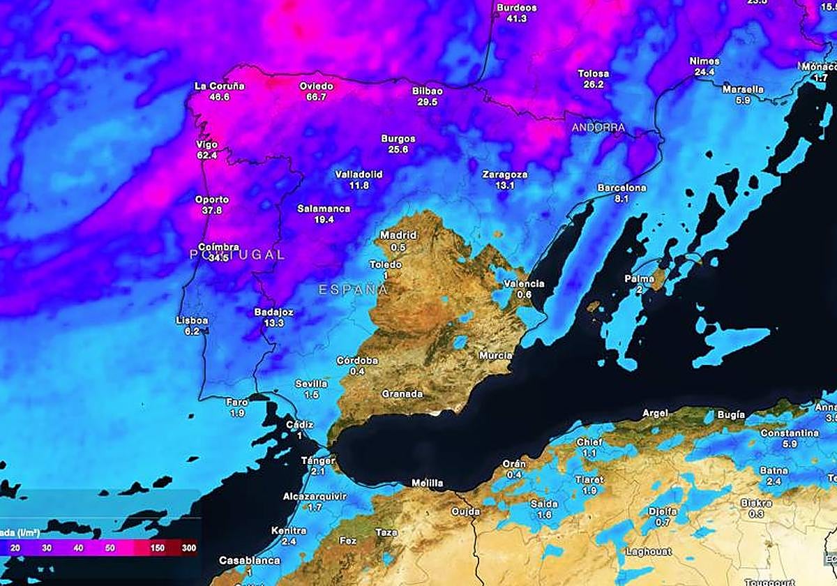
But which areas will be most affected by the rains? As Wingen explained, this week it will rain above the average for the season in the western half of the peninsula, Galicia, the Cantabrian Sea, the Ebro valley, parts of Catalonia and the Pyrenees. In contrast, the week will be normal or slightly dry in the centre and south. "More than 50mm could accumulate in Galicia, Asturias, Cantabria, Huesca and the Pyrenees. These amounts could vary greatly in future outings, due to the uncertainty inherent in the weather system," he warned. On the other hand, little or no rain is expected in the southeast of the Spanish mainland, east of Castilla-La Mancha, the Balearic Islands and the Canary Islands.
Saharan dust and muddy rains
The Meteored forecast also expects an influx of suspended dust in the atmosphere from North Africa. The eastern half of the Spanish mainland and the Balearic Islands will be the most affected areas. "The maximum concentrations will arrive between Wednesday and Thursday, with mud showers that may be important on Thursday in the Balearic Islands, Catalonia, eastern Cantabrian and points of the western Pyrenees," the forecasters pointed out.
In addition, the influence of the 'Dana' will leave a cool atmosphere in the western half of the Iberian Peninsula and the Canary Islands, with anomalies of 1 to 3C below average. On the shores of the Mediterranean and especially in the Balearic Islands, there will be a warm entry between Monday and Thursday, with temperatures slowed down by the dust in suspension, but still high, especially at night.
Tomorrow, Monday (17 June), temperatures will exceed 34-35C in the Guadalquivir valley, the Ebro valley and parts of the southern plateau. Occasionally, temperatures may reach 36-38C in the Andalusian provinces of Cordoba and Jaén. On Tuesday, the heat will persist with more than 34C in the Ebro valley, eastern Andalucía and Mallorca.
On Wednesday and Thursday, temperatures will drop but will continue to exceed 30C in the Levante and Balearic Islands. Tropical nights are also expected for most of the week along the Mediterranean coast and coastal areas of both archipelagos. On Monday and Tuesday, the Ebro and Guadalquivir valleys will also be affected.