Weather forecast
What will the weather be like this Easter in Malaga province and on the Costa del Sol?
Despite the forecast from Spain's state weather agency (Aemet), it is hoped that some of the large-scale Holy Week processions will still be able to go ahead


Malaga
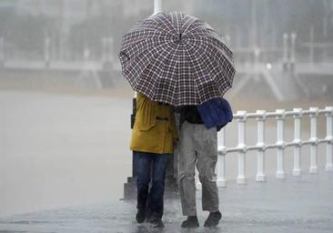
Spain's state weather (Aemet) is forecasting widespread rainfall for most of the remainder of Holy Week in Malaga province. So much for the headline in a broad stroke. However, we will have to delve down into the details and take it day by day, because there will also be some large clearings that will last for several hours and will allow the departure of some of the large-scale Semana Santa processions.
To start with, the head of Aemet in Malaga, Jesús Riesco, warned that it is necessary to differentiate between the province and the city, as the presence of rain will be less in the city and on the coast than in inland areas. With this is mind, the passage of successive storms will mean that it will rain almost every day in the province, while on the coast it is likely to fall almost every day, but with the proviso that the skies will clear for long period, offering windows of opportunity for numerous processions, especially in the afternoons, which is when most of them are scheduled to take place.
This Holy Monday the 'Dana' (high altitude depression) will depart, although a cold front will arrive just behind it, with a change of air mass and a westerly wind. With this, the 'calima' Sahara dust haze will be replaced by a notable drop in temperatures, which will reach 20C today and only 16 degrees on Holy Tuesday in Malaga city and around 12C in Antequera and Ronda. In addition, the westerly wind will be noticeable, and will blow strongly, especially tomorrow.
The Aemet forecast for this Monday is that from early evening (around 6pm) clearings will open up. "There will still be some showers, but they will tend to decrease considerably once this first front has passed", explained Riesco. Therefore, although with some timetable adjustments, most of the processions in the city could go out this Easter Monday, pending the latest weather forecasts.
Some light rainfall is not ruled out, less likely from 7 to 8 in the evening. Inland, on the other hand, the front will bring downpours throughout most of the day, and in fact in Antequera the showers will not end until midnight," said Riesgo
Will Holy Tuesday be saved?
On Tuesday there will again be showers in the province, although they will be less likely in Malaga city due to the westerly trend. In fact, it may not rain at all in the city, or only in the first half of the day, but not in the second part.
From Holy Wednesday onwards the scenario will be similar, although there is still uncertainty as to the timings, so we will have to wait for the last minute. Fronts will continue to arrive in Spain but some days it may not rain in the afternoon, so there is hope for the processions. "It's not clear yet, we have to take it one day at a time," said the meteorologist.
In this case, the problem is the entry of a different storm, which will move in between Wednesday and Thursday and it remains to be seen how it will affect the second half of the week in the province. Initially, it could leave showers every day, but it remains to be seen how often.
In addition to all this, for Tuesday and Wednesday, Aemet is maintaining a yellow 'risk' warning for coastal phenomena with westerly winds of 50 to 60 km/h (force 7) and waves of two to three metres.