Weather
Storm Konrad set to batter Spain: How will it affect Malaga and the Costa del Sol?
State weather agency Aemet has activated new yellow 'risk' warnings for accumulated rainfall of up to 40mm across the majority of the province for most of Thursday


Malaga
Don't put away your umbrellas just yet, there's more rain to come. The storm train has given a brief respite today but tonight and on Thursday the rain will return to Malaga province, following the arrival of a new high-impact Atlantic storm, which has been christened Konrad by the authorities in neighbouring Portugal, which will sweep across Spain on Thursday. In the case of Malaga, the state weather agency (Aemet) has activated a new yellow warning (slight risk) for the 13 March, due to a combination of various phenomena.
Noticia relacionada
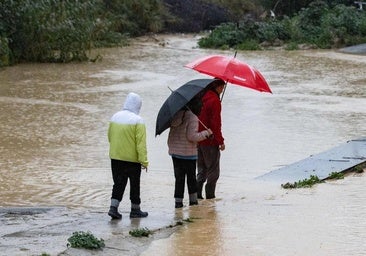
First the rain, with up to 15mm accumulated in one hour, and up to 40 in twelve. This could happen in Malaga city, on the Costa del Sol, the Guadalhorce valley, Axarquia and Ronda areas. The statistical probability of this happening is quite high, from 40 to 70 per cent.
In addition to possible heavy downpours, there will be warnings for thunderstorms and winds, with maximum gusts of up to 70 km/h.
In addition to the above, Aemet also warns of possible coastal phenomena, with winds from the west and southwest of 50 to 60 km/h (force 7) and waves of 2 to 3 metres in significant height. Furthermore, in this case the sea storm will be worse, as it will be combined with "combined sea", which is combination of wind and swell, to give rise to a westerly swell that may reach four metres in height.