
Malaga
On 8 September, an earthquake measuring 6.8 magnitude triggered the disaster in Morocco. The proximity of the epicentre of this major earthquake to southern Spain is no coincidence.

Tectonic plates
Plate boundary
Convergent or destructive boundary
North American
Eurasian
African
Antarctic
South American
Australian
Source: USGS
E. H.

Tectonic plates
Plate boundary
Convergent or destructive boundary
North American
Eurasian
African
Indian
South American
Australian
Antarctic
Source: USGS
E. H.

Tectonic plates
Convergent or destructive boundary
Plate boundary
Eurasian
Arabian
Philippine
North American
African
Indian
Pacific
Pacific
South American
Australian
Nazca
Antarctic
Scotia
Source: USGS
E. H.

Tectonic plates
Convergent or destructive boundary
Plate boundary
Eurasian
North American
Juan de Fuca
African
Arabian
Philippine
Caribbean
Indian
Cocos
Pacific
Pacific
South American
Nazca
Australian
Antarctic
Scotia
Source: USGS
E. H.
Friction between the African (Nubian) and Eurasian tectonic plates, just north of the neighbouring continent, is responsible for most of the earthquakes documented in Spain since the 14th century by Spain's National Geographic Institute. This means that most of the epicentres of these earthquakes are located in southern Spain, specifically in Andalucía, Murcia and Alicante - on land - and in the Gulf of Cadiz and the Alboran Sea - on water.
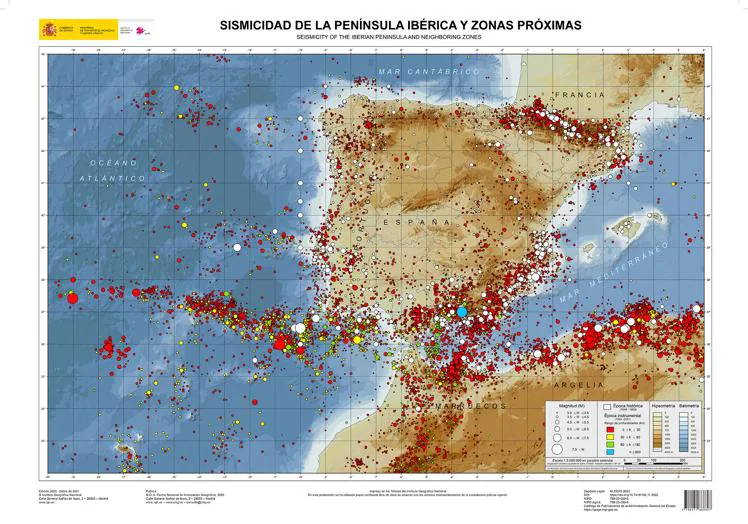
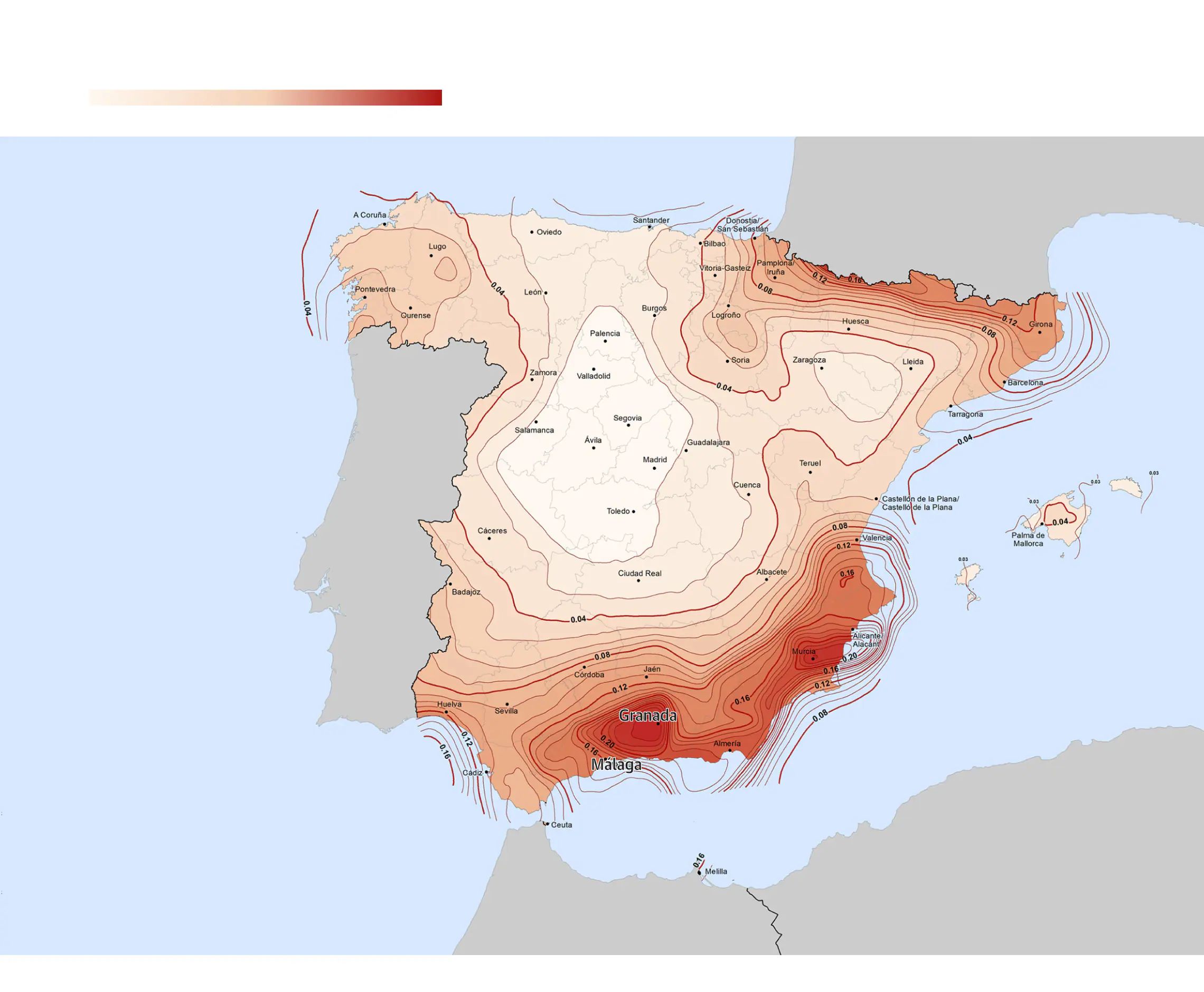
Records over the years of these earthquakes and their parameters, together with other scientific analyses related to the geological characteristics of the terrain, allows the National Geographic Institute to produce the seismic hazard map of Spain. It was last updated in 2015 and represents the probability of earthquakes with a hazard magnitude in a return period of 475 years.
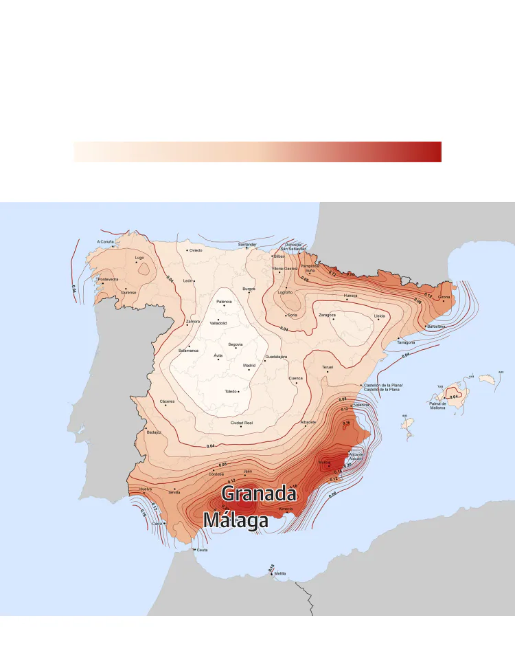
Seismic risk in Spain
Return period: 475 years,
ground acceleration data
Low risk
High risk
Source: Instituto Geográfico Nacional
E. H.
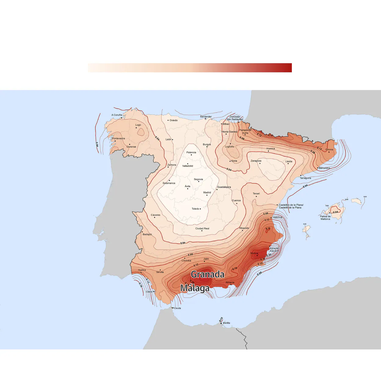
Seismic risk in Spain
Return period: 475 years,
ground acceleration data
Low risk
High risk
Source: Instituto Geográfico Nacional
E. H.
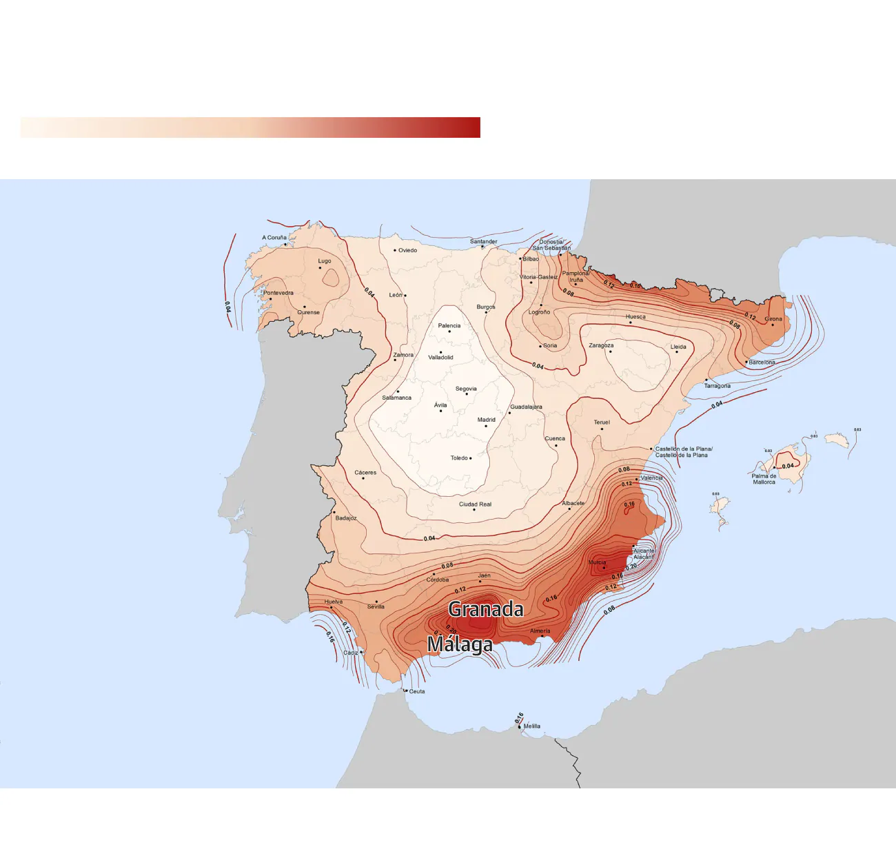
Seismic risk in Spain
Return period: 475 years, ground acceleration data
Low risk
High risk
Source: Instituto Geográfico Nacional
E. H.
Seismic risk in Spain
Return period: 475 years, ground acceleration data
Low risk
High risk
Source: Instituto Geográfico Nacional
E. H.
The map makes it clear where the most dangerous areas of the country are located. Next to the Pyrenees, Murcia - with influence in neighbouring Alicante - and Granada - with effects in Malaga, especially in the regions of Axarquía in the east and Nororma in the north.


An earthquake in detail
Hypocentre
Depth
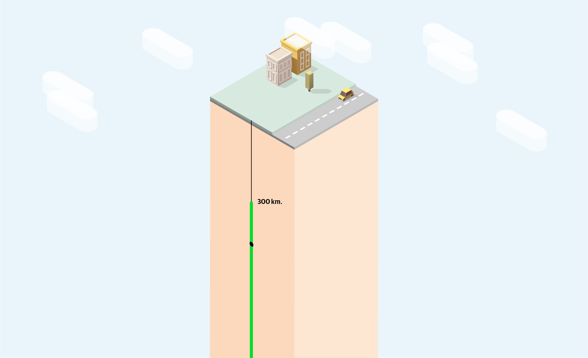
Deep-focus
Intermediate
Shallow
Epicentre
Area
Intensity (Mercalli scale)
Magnitude (Moment Magnitude Scale)
AUX STEP FOR JS
The National Geographic Institute compiles a list of the biggest earthquakes in the history of Spain based on their intensity, or Mercalli scale, which is determined by historical records, journalistic references, etc.
The list enumerates as many as 27 major earthquakes, from the year 1048 to the most recent one in Lorca (Murcia) in 2011. Of these 27, 17 - 6 out of every 10 - had their epicentre in or particularly affected Andalusian locations, such as the first one documented in Malaga, in 1494, or the one in 1680, which had its epicentre in Alhaurín el Grande.
Map of earthquakes in southern Spain
But technology, specifically a seismograph, provides a more accurate record. The National Geographic Institute has stored objective data on all earthquakes with an epicentre in Spain or adjacent areas for the last 100 years. Seismographs, in addition to the magnitude on the Richter or Moment scale, also record the exact date and time of the earthquake, the location of the epicentre and the depth of the hypocentre.
The five biggest earthquakes in the south of Spain in the last 100 years
Dúrcal (Granada) | 7.8
Nigüelas (Granada) | 6.2
Jimena de la Frontera (Cadiz) | 5.5
Almogía (Malaga) | 5.4
Castillo de Locubín (Jaén) | 5.3
AUX STEP FOR JS
The following interactive map shows all earthquakes with a magnitude greater than 3 with an epicentre in the south of Spain. The colour code represents the depth of the earthquake, with the earthquakes painted in red being the most dangerous, as their hypocentre is closer to the land or sea surface.
The area of Granada is not only one of the areas with the highest concentration of earthquakes, but also the majority of these earthquakes have a shallow depth (hypocentre at a depth of less than 70 kilometres). The area of Malaga with the highest concentration of epicentres is on the west coast (around the maritime-terrestrial limit of Fuengirola, Benalmádena and Torremolinos), although they are earthquakes of intermediate depth (70-300 kilometres).