Weather
Red 'extreme risk' alerts activated for torrential rain in Spain ahead of arrival of 'Dana' Alice
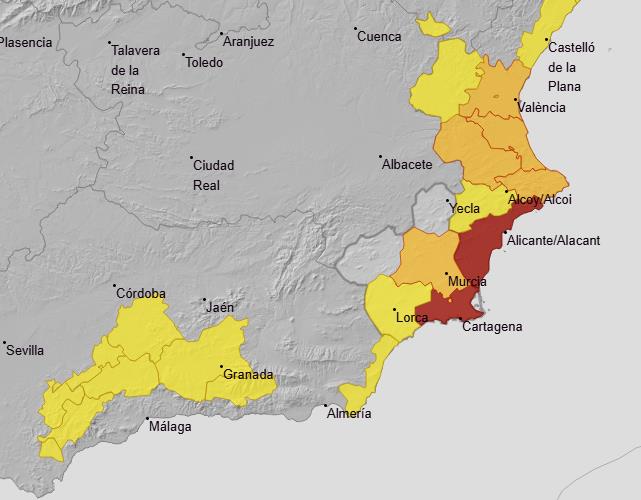
State weather agency Aemet has warned of the "extraordinary danger" of flash flooding in some areas of the country on Friday
Europa Press
Valencia
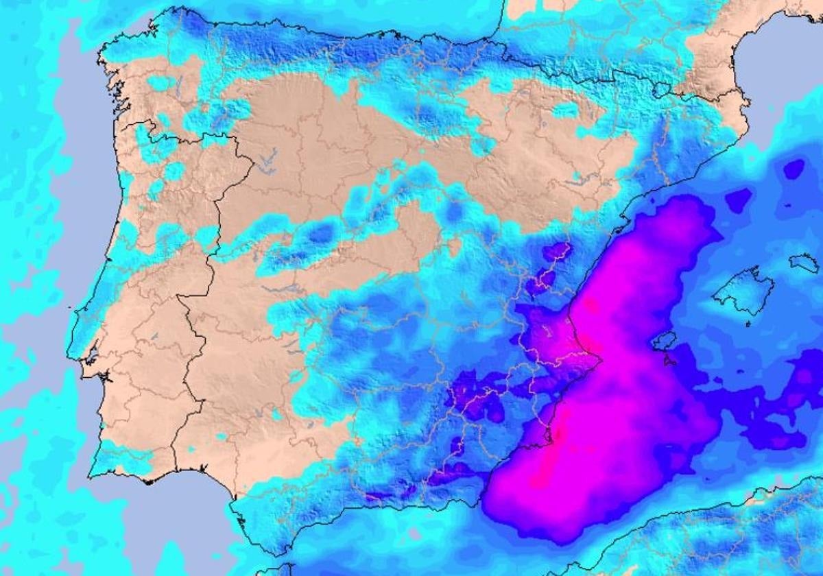
Spain's state meteorological agency (Aemet) has issued red (extreme risk) weather warnings from Friday at 10am in the southern coastal regions of Alicante and Campo de Cartagena and Mazarrón. "Extraordinary danger. There may be floods and flash flooding," it warned in a message on X.
⚠️AVISO ESPECIAL | Lluvias muy fuertes y persistentes en el tercio este peninsular y Baleares.
— AEMET (@AEMET_Esp) October 9, 2025
➡️En puntos del área mediterránea las lluvias podrán ser torrenciales, con posibles inundaciones y crecidas súbitas. Extrema las precauciones.
+ info 👉https://t.co/48Lsr8R9TN pic.twitter.com/ew0qJ9zEzx
In addition, it has announced that it is maintaining the warning for the 'Dana' named Alice, which until Monday could leave between 250 and 300 mm of rain in the area around Cape Nao, particularly the coastal and pre-coastal areas of Valencia and Alicante. The state agency warns of the "potential danger" of the situation, as the downpours could lead to local sudden and flash floods in low-lying areas, streams and wadis.
"There is a high uncertainty in the position of Alice and its interaction with surface flows, which will determine the areas of greatest adversity each day, so detailed monitoring of forecast updates and warnings is recommended over the next few days," he stresses.
Aemet expects heavy downpours on the coast of Tarragona, Barcelona and Valencia from the early hours, which throughout the day will extend to Ibiza and Formentera, the rest of Murcia, the eastern half of Andalucía and southern Castilla La Mancha. Additionally, the warning does not rule out that they may also occur in other areas of Castilla-La Mancha, Catalonia and the central system.
Related story

The state agency also predicts that these downpours, which would move slowly and could regenerate with the contribution of surface moisture, would be accompanied by thunderstorms, hail and reach strong or very strong intensity, even torrential. This is more likely to happen on the coasts of Valencia, Alicante and Pitiusas, where it could exceed 100mm in four or six hours.

Aemet forecasts that the peak days will be Friday and Saturday, when northeasterly winds will reach their maximum intensity. During these two days, the heaviest showers are expected in Valencia, Alicante and Murcia, where they will be locally very strong, probably torrential, and with accumulated rainfall that could exceed 140mm in twelve hours.
According to Aemet, the storms will extend to the south of Catalonia, the north of the Valencia region, the east of Castile-La Mancha and Andalucía, especially in the Baetic Mountains. On Sunday, the surface wind will lose intensity, but the situation of instability is expected to continue at medium and high levels and wet winds at low levels, with the most intense downpours, locally strong or very strong.
Rain will be more likely between Cap de la Nao and the mouth of the Ebro for another day, but may reach the interior of the Valencia region, the southeast of Aragon and the Balearic Islands. Winds will continue to lose intensity on Monday. Although rain could extend as far as the centre of the mainland, the most likely and intense downpours are again forecast for the Valencia and Balearic Islands.