Eleven regions issued with weather warnings as Spain shivers with widespread snow and frost
The weather agency Aemet is forecasting temperatures down to -10C in some areas

ENRIQUE MIRANDA / EUROPA PRESS
MALAGA / MADRID.
Freezing, cold weather will hit practically all of Spain today, including Andalucía. The weather agency Aemet is forecasting a general drop in temperatures in the region this week after they rose slightly at the weekend.
The skies will continue to be slightly cloudy or clear in general, although occasional rain - generally weak - on the coast and in the mountains cannot be ruled out. The snow level will drop to around 500-700 metres and there is a high probability of frosts inland.
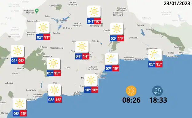
In the region’s provincial capitals, the minimum will be around 0 degrees in several cities. Granada will register -1C , Córdoba 0 degrees and Jaén 1. The highest minimums will be in Cadiz and Malaga, with 7 degrees. However, in the countryside there will be minimum temperatures below 0 degrees in various areas. In Malaga province, towns such as Antequera (-1) or Archidona will register minus minimums, and Ronda will be very close (1 degree).
Snowfall in much of Spain
Snowfall in the eastern Cantabrian and northern Iberian system and widespread frosts will predominate this Monday, January 23, in practically all of Spain, according to Aemet’s forecasts.
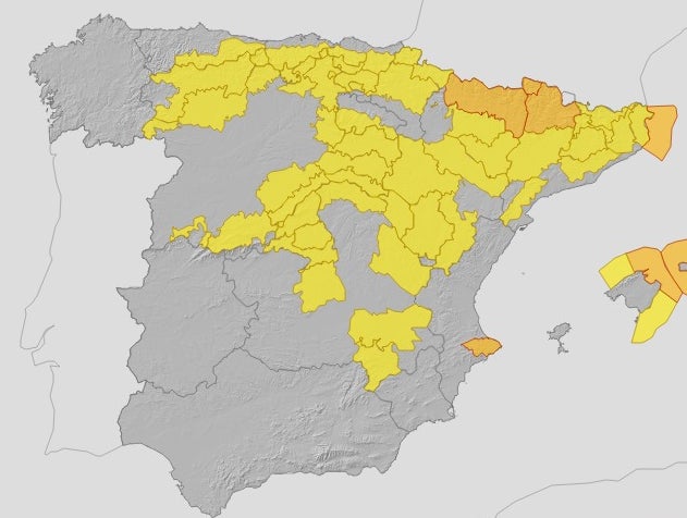
Eleven regions will have severe weather alerts activated for cold, wind, snow or rough seas. Specifically, Ávila, León, Palencia, Salamanca, Segovia, Soria, Zamora, Albacete, Cuenca, Guadalajara, Barcelona, Gerona, Tarragona, Madrid, Mallorca, Ibiza and Formentera and Navarra will be on yellow alert for temperatures that will be around -4 and -8ºC, while Lleida and Huesca will be on amber alert for values close to -10ºC.
In the case of snow, this will be present in the eastern Cantabrian and northern Iberian system. More specifically, in Cantabria, Burgos, La Rioja, Álava, Guipúzcoa and Vizcaya.
The strong gusts of wind will be the main feature this Monday in Huesca, Zaragoza, Menorca and Gerona, Lleida, where they will reach up to 80km/h. Due to this wind, Castellón and Tarragona will be on yellow alert due to high waves and Gerona on amber alert due to waves that could reach up to five metres in height.
In general, the Aemet forecasts cloudy skies or with cloudy intervals and rainfall in the Balearic Islands, the Pyrenees, the eastern Cantabrian Sea and the Alto Ebro. The rains will be somewhat more intense around the Balearic Islands, where they may be accompanied by storms, and weaker in the other areas.
Precipitation will be in the form of snow above about 300/500 m in the eastern Cantabrian Sea, above 400/600 m in Majorca and at any level in the Pyrenees. In the rest of the Peninsula, this Monday, light cloudy or clear skies will predominate, although throughout the day the cloudiness will increase in the Cantabrian mountain range, the eastern plateaus, the Central and Iberian systems and the Alborán zone, without some weak and isolated snow inland being ruled out.
In the Canary Islands, there will be cloudy intervals, with rainfall in the north of the islands, and a chance of light, scattered showers in the rest.
Temperatures will not see much change, as there will be widespread frosts inland on the Spanish mainland. These will be greater high areas, especially in the Pyrenees. The winds will be from the north on mainland Spain and the Balearic Islands, and stronger in the Pyrenees, the Ebro valley, Ampurdán and the eastern Balearic Islands. Moderate northeast trade winds in the Canary Islands.