Weather
Weather alert issued for Costa del Sol on Monday: Aemet forecasts heavy rain, storms and hail
Spain's state weather agency also expects wind gusts from the east of 50 to 60 km/h in the Axarquia area of Malaga province

Malaga
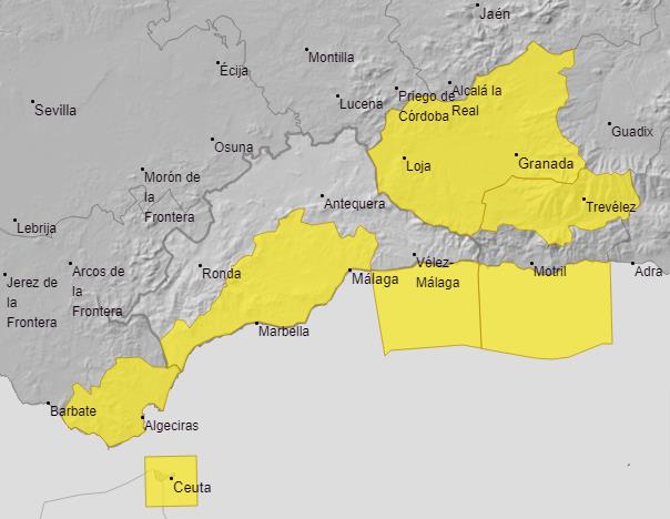
The week will start with yellow 'risk' warnings in Malaga province due to the threat of heavy rain and gusts of wind. The weather forecast from Spain's state meteorological agency (Aemet) highlights a situation of "instability in the Alborán Sea area off the Costa del Sol and the southern third of the Spanish mainland", with abundant cloudiness and occasional rainfall accompanied by storms "which may be locally heavy in coastal areas".
For this reason, Aemet has activated warnings for Monday, 3 February, in the province of Malaga - in the western Costa del Sol, Malaga city, Guadalhorce valley and in the Axarquia area - where it expects very cloudy or overcast skies, accompanied by light to moderate rainfall.
As a result, in the area of the western Costa del Sol and Guadalhorce area the warning is activated, until 9pm, for accumulated rainfall of 15 mm in one hour. This rainfall may also "occasionally be accompanied by thunderstorms and hail". Meanwhile, in the Axarquia area another yellow alert is activated due to the forecast of wind from the east of 50 to 60 km/h (force 7) and waves up to 3 metres high on the coast.
As for temperatures, for Monday, minimum temperatures are expected to rise and maximum temperatures to fall slightly, "locally unchanged in the eastern third of Malaga province". Meanwhile, the snow level is expected to be around 1,300 metres in the province, according to the weather forecast.
Storms and snowfall on the Spanish mainland
In the national forecast for the Spanish mainland, the situation of instability in the Strait of Gibraltar, Alboran Sea and the southern third of the country, "could end up affecting other regions of the southeast quadrant, including the Central System and the south of the Balearic Islands, generally tending to decrease throughout the day". In the rest of the mainland and the Balearic Islands, an anticyclone is expected to tend to establish itself, "even with abundant cloudiness at the beginning that could leave some light rain in the Cantabrian Sea and with a tendency to clear. Snowfall is expected in the southeastern mountains at an altitude of around 1300/1400 m, with significant accumulations. In the Canary Islands, cloudy skies with precipitation in the north of the mountainous islands", Aemet specified.
As for temperatures, maximum temperatures "will tend to increase in the Balearic Islands and in the northern half of the mainland, locally notable in the inland areas of Girona, and with decreases in the southeast and Alborán Sea". Aemet states that "increases in minimum temperatures will predominate in the Balearic Islands and in the centre and east of the peninsula and decreases in the western third. There will be no changes in the Canary Islands. Frosts will lose intensity, although they will continue to affect mountains in the northern half and southeast of the mainland, the northern plateau and, in a more scattered way, to the east of the south. Moderate frosts are expected in the Cantabrian mountains and locally heavy frosts in the Pyrenees.