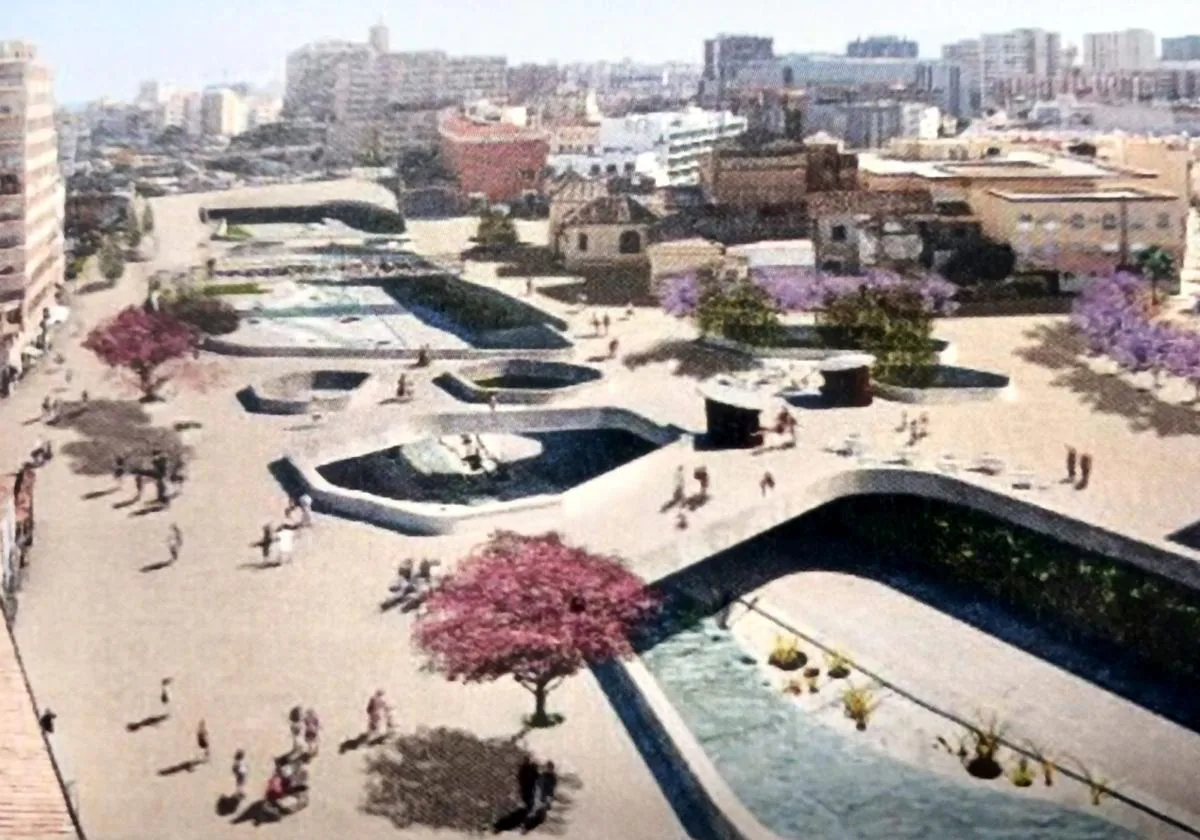
This is Malaga's ambitious project to open up large pedestrian areas over its riverbed
The idea is to create 'plaza bridges' and divert traffic through underpasses on either side
The plan drawn up by Malaga city hall five years ago to integrate the normally dry Guadalmedina riverbed into the urban landscape is "the most far-reaching project for open areas that remains in the city", according to the document that the municipal urban planning department sent more than two years ago to the Andalusian regional government for an environmental assessment.
The Junta de Andalucía endorsed the environmental report at the end of July this year with a few requests for justifications, but it reflects in detail the commitment to generate wide pedestrian spaces on the riverbed, without reducing its capacity to hold water when necessary.
The project is based fundamentally on the concept of so-called 'plaza-bridges', which are essentially a type of cover over the river to create pedestrian spaces that connect the two sides. SUR has had access to one of the recreations produced by the technicians hired by the city hall to shape the Guadalmedina plan.
The image shows what the transformation of the area around Santo Domingo church and Pasillo Santa Isabel would look like with these 'plaza bridges'. Underpasses for traffic on either side of the river would be built, which would mean gaining more space for pedestrians.
For this area close to the city centre, "a solution is planned that extends the pedestrian character of the historic centre towards the neighbourhoods located on the right side of the river and that does not change the perception of the river as a geographical feature that constitutes the physiognomy and landscape of the city", states the environmental document.
"Since the waterway allows it, the connection should be made at street level, eliminating physical barriers that impede the free transit of pedestrians, giving visual continuity between districts and extending the paving and the character of the centre's streets," adds the report carried out by architects Sfera.
Plazas on the river bed
The plan will mean changes to "the old stone bridge located in front of Santo Domingo church", although the project respects and maintains the Alemanes bridge, built in 1909.
"The execution of plaza-bridges is more economical and respectful of the physical environment than completely covering over this section of the river; it generates spaces for citizen enjoyment of higher spatial quality, and proposes an original intermediate solution for the specific case of Malaga," adds the document prepared by the city hall.
The Junta's water department has already given its initial approval to the mayor's proposal
The biggest operation proposed in the plan, and which for mayor Francisco de la Torre is a priority, is to cover a stretch of some 350 metres between the Aurora and Armiñán bridges to create a large plaza over the riverbed linking the centre with the Trinidad district.
This large new pedestrian area could have a surface area of 19,365 square metres and would also be perforated with gaps to provide a view of the riverbed. De la Torre has said that he imagines it as "the largest plaza in Malaga", which will be "landscaped and with fountains".
Until a few years ago the regional government, which has jurisdiction over the river, was reluctant to carry out this type of project, but, as SUR reported on 21 February last year, a first report by the regional water department on the plan does not oppose it.
"There would be no objection to the initiatives included in the special plan for the Guadalmedina," concludes the public water board's statement, as it "protects, improves and recovers the channelling of the Guadalmedina and its surroundings, which are mainly urban".
As such, everything seems to be on track for this ambitious city project. However, it still needs to be definitively validated at an environmental level by the Junta, approved at a municipal level, and obtain the necessary financing, a path that still seems a long way off.

