Weather
Top TV weatherman alerts these areas of Spain to the arrival of more torrential rain
The renowned meteorologist has warned that instability will continue this week due to the arrival of new Atlantic fronts to the Spanish mainland


Madrid
The 'Dana' weather depression Alice has left its mark with a very complicated weekend in Spain. The torrential rains caused by this storm seriously affected many parts of the Mediterranean, such as Alicante, Murcia, Ibiza, Formentera and Tarragona. Since last Friday, these regions have been experiencing some critical moments due to flooding, which even forced the state meteorological agency (Aemet) to activate red and amber warnings due to the storms.
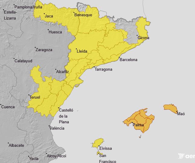
Although the worst seems to be over, the yellow and amber warnings for «very heavy and persistent showers« in areas of the mainland Mediterranean and the Balearic Islands are still active this Tuesday. The agency has also put the focus on the yellow warnings that will be in areas of central and eastern half of the peninsula, as Castilla-La Mancha, northern Catalonia or points of Aragon, where this last week had been spared from rain fronts.
Although the instability has been decreasing, as has its intensity, this relief will be short-lived, according to some weather experts. This is what meteorologist Mario Picazo has done in his latest forecast on the eltiempo.es portal, where he has advanced the arrival of «a new episode of torrential rains» that will affect Spain this week and that will complicate the environment in many provinces.
Mario Picazo warns of further torrential rains to hit Spain this week
The former Telecinco weatherman has reminded us in his forecast for the coming days that the rain will continue to be present during the first half of the week. «Instability will continue to be the dominant feature on the Mediterranean slope and in other areas of eastern Spain,« warned the expert.
It seems that the instability will tend to ease in the middle of the week after several days without a break. Even so, the rains will not move far away from the Spanish, explains the eltiempo.es expert: «It will give way to a new situation coming from the Atlantic. Between Friday and Sunday, a front will bring rain, lower temperatures and a more autumnal atmosphere over a large part of the country».
«Between Friday and Sunday, an Atlantic front will bring rain, cooler temperatures and a more autumnal atmosphere to much of the country»
This change in the weather in Spain will begin on Friday, when «a band of Atlantic rain» will reach Spain initially in Galicia. As the weekend progresses, this storm will spread towards the northwest of the mainland, leaving «moderate rainfall» and even persistent in some areas.
On Saturday, the first showers will begin to arrive inland, with scattered showers in the north and west, while in the Mediterranean it will calm down, although only for a short time. «The day will be one of transition, with some isolated thunderstorms and residual showers«, reminds the what is to come at the end of the week. In the Canary Islands there could also be «intermittent showers and heavy showers» due to the passage of a small storm.
It will be from Sunday when instability will return to Spain with the Atlantic front reaching the northeast of the mainland, leaving «a cooler and fully autumnal atmosphere». As it approaches the Mediterranean, the storm could leave «heavy rainfall in Catalonia, the north of the Valencian region and the east of Aragon».
Once again, the worst part will fall on the eastern half of the country and the Balearic archipelago, where «the most significant accumulations» will once again be concentrated. Looking ahead to this coming weekend, Mario Picazo has pointed out that «heavy rains could cause new flooding» in the same areas as 'Dana' Alice.
«The heaviest accumulations will again be concentrated in the eastern half of the Spanish mainland and the Balearic Islands. The probability of heavy rain could cause further flooding»
A new Atlantic front will change temperatures on the Spanish mainland, according to Mario Picazo
In addition to the rains, we will also see changes in the temperatures over the last few days, according to the weather expert. We will start the week with unusual values for the time of year, «between 3 and 5C» above normal, with maximums «between 25C and 30C or more in a good number of provincial capitals«. Somewhat cooler temperatures will prevail in the east of the peninsula and the Balearic Islands thanks to precipitation.
As Picazo explains, everything indicates that the thermometers will start to drop from Friday 17 October with the passage of this new Atlantic front. The area that will suffer most from this drop will be the north of the peninsula, while in the central areas and east there will still be «mild» values for the time of year.