Weather
Storm Olivier set to bring heavy rain, thunderstorms and plummeting temperatures to many parts of Spain
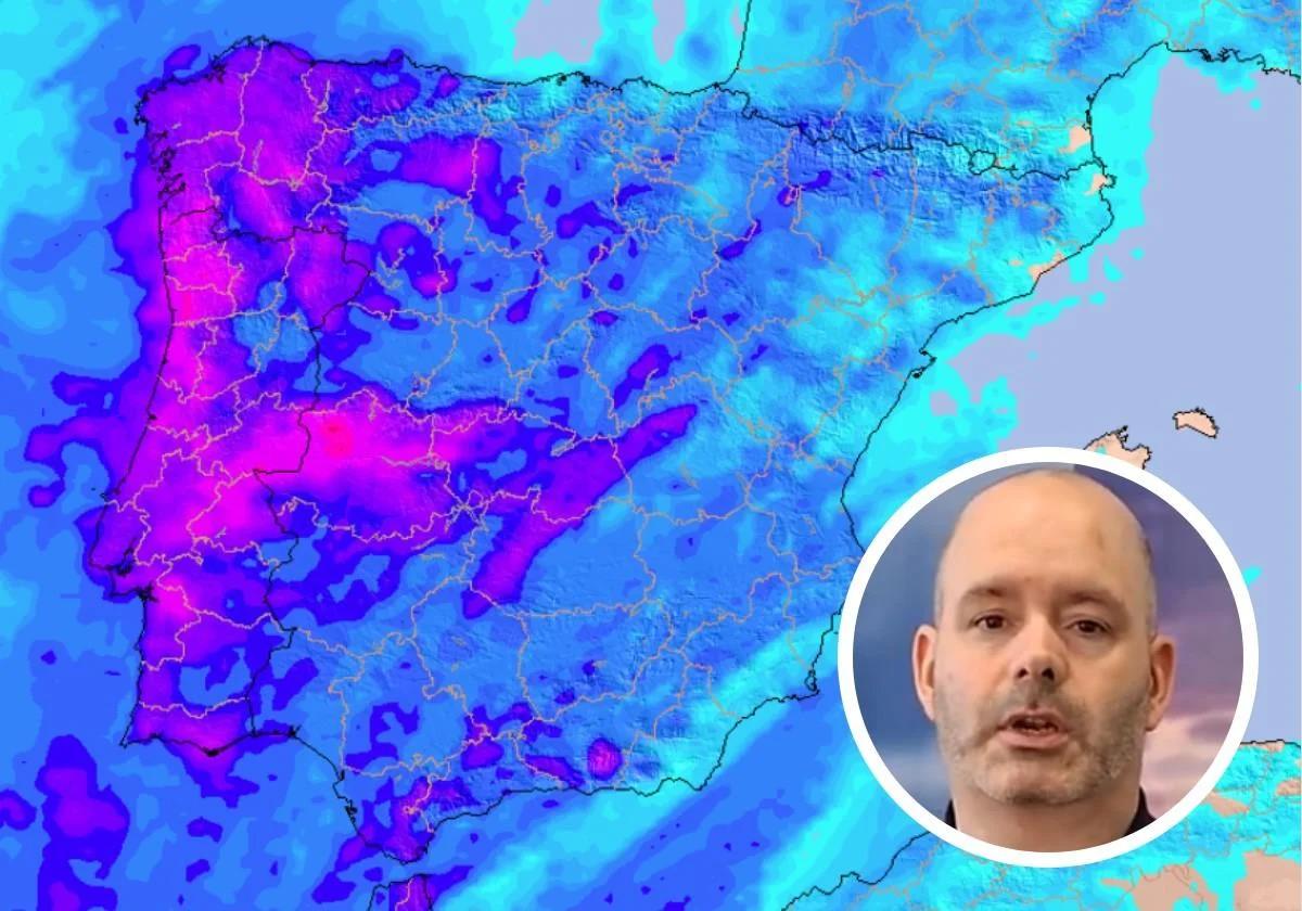
Rubén del Campo from the state meteorological agency (Aemet) has released a statement on what the weather will be like ahead of the first days of Semana Santa

Madrid
We will say farewell to the recent weather stability in Spain at the begining of Holy Week in 2025. As announced by the state meteorological agency (Aemet), storm Olivier - the 15th of great impact of the season - will arrive this Wednesday 9 April to the country, bringing rainfall to many parts of the Spanish mainland and cause temperatures to plummet thermometers in some provinces.
"The first days of Holy Week 2025 will see unstable weather due to the presence of storm Olivier, which, beforehand, will leave heavy rains in the Canary Islands," warned its spokesperson Rubén del Campo. "It will leave a first wet Easter weekend in many areas of Spain, especially in the south and west of our country," explained the Aemet weather expert in the video.
🌀 Nueva borrasca con gran impacto: OLIVIER (con dos íes)
— AEMET (@AEMET_Esp) April 7, 2025
⛈️Provocará el miércoles chubascos muy fuertes en Canarias, además de vientos intensos. El jueves traerá lluvias a la Península, que de cara al fin de semana afectarán a amplias zonas. Además, bajarán las temperaturas. pic.twitter.com/ri6S55EKNp
Storm Olivier will bring cold temperatures and thunderstorms to many parts of Spain.
Since Tuesday, storm Olivier has been leaving some rain in the Canary Islands, where this Wednesday we will see some showers that could be heavy and accompanied by strong winds. These showers will also continue throughout Thursday in the archipelago, although they will become less intense towards the end of the day.
To see the effects of the storm on the Iberian Peninsula we will have to wait until Thursday 10 April, when the new rain front will approach from the south to leave widespread rain. This will last at least until the first weekend of Holy Week, and will be accompanied by strong wind and cold air at altitude, which will bring the temperatures down.
📢 Mañana la 🌀 #BorrascaOlivier dejará lluvias y tormentas ⛈️ en #Canarias. 👣 Después pondrá rumbo a la Península.
— Meteored | tiempo.com (@MeteoredES) April 8, 2025
👇 Los detalles de la previsión con @Divulgameteo. https://t.co/N4y6OL9QtA pic.twitter.com/B3lluzf2aT
During these next few days, we will see heavy rainfall in Galicia, Castilla y León, Extremadura and western Andalucía, where it could last until the first days of Holy Week. Precipitation will also extend over the Cantabrian sea, Madrid, the Balearic Islands and Castilla-La Mancha throughout Thursday, although it will be widespread in almost all of Spain from Friday onwards.
According to the state weather agency, the Spanish provinces most affected by this new rain front could be Cáceres, Ávila, Badajoz and some parts of Huelva, Seville and Cadiz , where 'calima' sand dust from the Sahara desert could also arrive in the next few hours. We could also see significant rainfall accumulations in the Cantabrian sea and the Canary Islands, where more than 50-70 mm could be recorded.
This is what the weather will be like at Easter according to Aemet
It seems very likely that the first weekend of Holy Week, which also coincides with 'Operation Exit' on the roads as people head off their holidays, will be wet. According to Rubén del Campo, these first days "will be cool" and "rainy" in most of the country: " Temperatures will drop and there will be rain in most of the Peninsula," said the Aemet spokesperson.
The areas with the heaviest rainfall during Palm Sunday could be Galicia, Castilla y León, Extremadura, some parts of central Spain and Andalucía, especially in the west of the region. Less significant will be in the east of the country, although heavy showers are not ruled out in the Balearic Islands throughout the weekend.
¿Qué tiempo esperamos para Semana Santa? Los pronósticos hablan de unos primeros días pasados por agua en muchas zonas, como consecuencia de la borrasca Oliver.
— AEMET (@AEMET_Esp) April 8, 2025
¿Y después...? 🤔
📹 Te lo contamos en este vídeo. pic.twitter.com/Zvxjd9hr27
As for the rest of Holy Week, it seems that uncertainty is growing as to what might happen, although everything points to this unstable atmosphere continuing: "From Maundy Thursday onwards, it is difficult to make a reliable forecast yet, but it is likely that the probability of rain will be greater the further north of the Spanish mainland and that the south will be left with less probability of precipitation. This will have to be confirmed at a later date," said the Aemet meteorologist.