Weather
Yellow alerts for heavy rain activated in Malaga province today with warning it could leave deposits of mud
Spain's state weather agency Aemet is forecasting accumulated rainfall of up to 60mm in 12 hours, accompanied by thunderstorms in the capital of the Costa del Sol and across much of the area


Malaga
After the 'Dana' strom that left heavy rainfall on Monday, which totalled up to 161mm in parts of the province such as the Serranía de Ronda, Malaga is preparing to receive another storm that is expected to be quite powerful. It will be a completely different phenomenon to the previous one, with widespread rainfall. In view of this scenario, the Span's state meteorological agency (Aemet) has activated a new yellow warning for today (Wednesday 5 March).
The warning will be in force throughout the province except Axarquia (the capital, the Costa del Sol, the region of Guadalhorce, Antequera and Ronda) from nine o'clock in the morning and will continue throughout the day with a forecast of 60mm (initially the forecast was 40) falling in 12 hours and 20mm in just one hour. Aemet has raised the probability of showers to 100% from midday, which will be accompanied by thunderstorms.
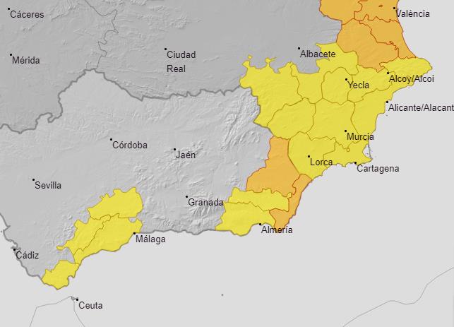
The Aemet forecast for this 5 March in Andalucía points to "intervals of very cloudy skies accompanied by scattered showers, without ruling out locally heavy showers in the afternoon, accompanied by thunderstorms in the western third". In addition, there could be 'calima' Sahara desert dust in suspension in the Alboran Sea, "which could produce deposits of mud". Temperatures, meanwhile, will remain high with minimums of 12C and maximums of 20 degrees in the case of Malaga where, in addition, strong gusts of up to 30 kilometres per hour will blow, especially in the afternoon. At the moment there are active warnings - in addition to Malaga - in Cadiz and Almeria provinces. In the latter, there are amber warnings for accumulated rainfall of up to 80mm in 12 hours.
The regional spokesperson for Aemet, Juan de Dios del Pino, explained that Andalucía will feel the effects of a 'Dana' until Thursday and then, on Friday, give way to an Atlantic storm that will also leave rainfall throughout the region, "which may be heavy at times".
Showers all weekend
From Friday and, for the time being, at least until next Sunday, a train of weather fronts will gradually spread across the whole of Malaga province. "They will leave rainfall starting in Huelva and spreading throughout Andalucía. They will be rains of a different nature, widespread and persistent", according to Aemet. So much so that over the course of this week more than 100mm may accumulate in some places. "The two phenomena together (first a Dana and then an Atlantic storm) will leave significant amounts," said Del Pino.
The European weather prediction model points to the area between Marbella, Estepona and the upper Guadalhorce valley (precisely where the reservoirs are located) as the area where the most water will accumulate, up to 120mm, according to the data provided by this mathematical system. Aemet does not rule out the possibility of the rains extending into the first days of next week, at least until Monday. For now, the probability of showers for that day is 90% in Malaga city.