Weather
Storm Jana continues to batter Malaga and the Costa del Sol with weather warnings for heavy rain and thunderstorms extended until Tuesday
The air mass from the Atlantic is laden with moisture and strong winds: today there are yellow alerts activated in the province for accumulated rainfall - and there is another train of weather fronts on the way this week
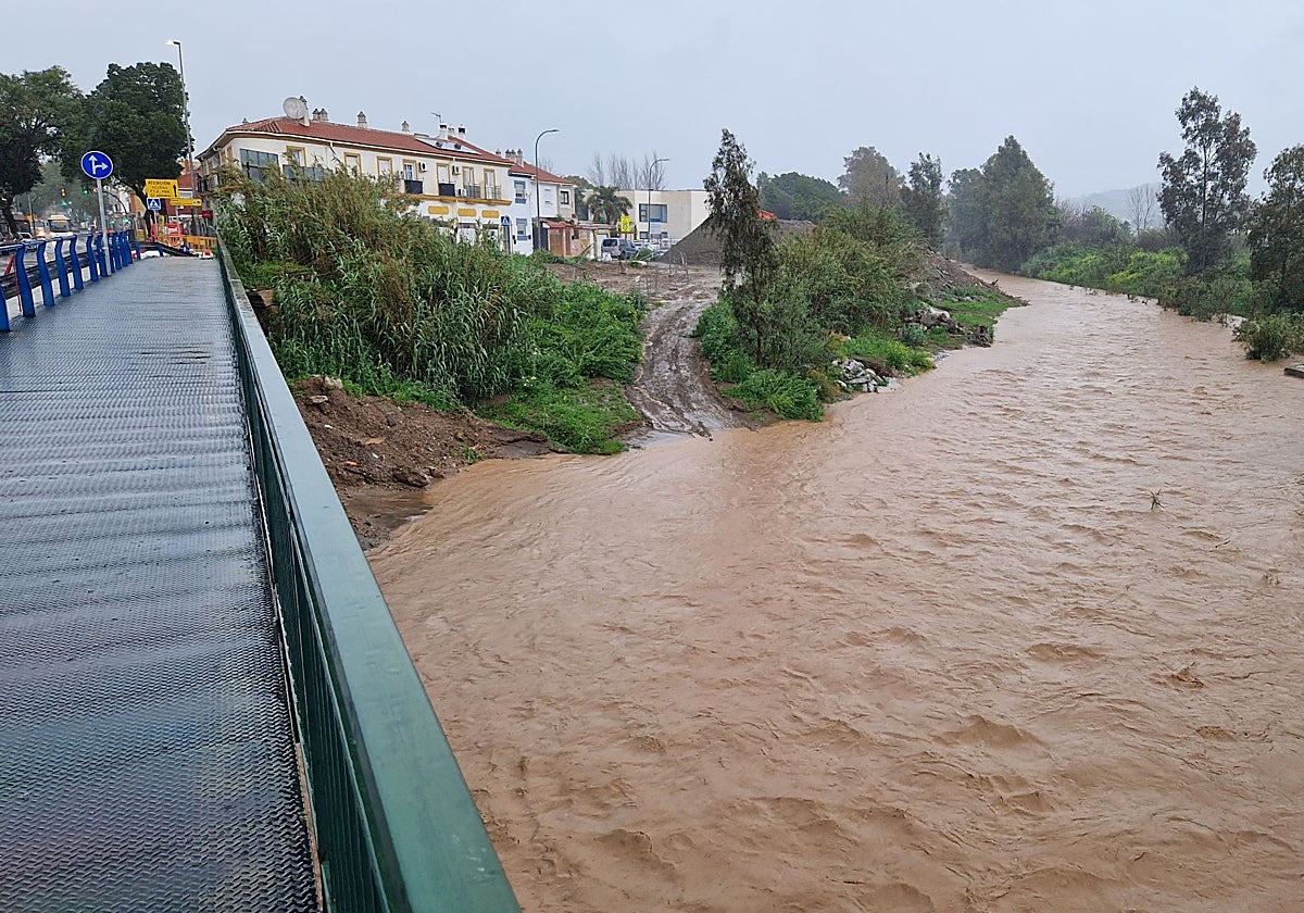

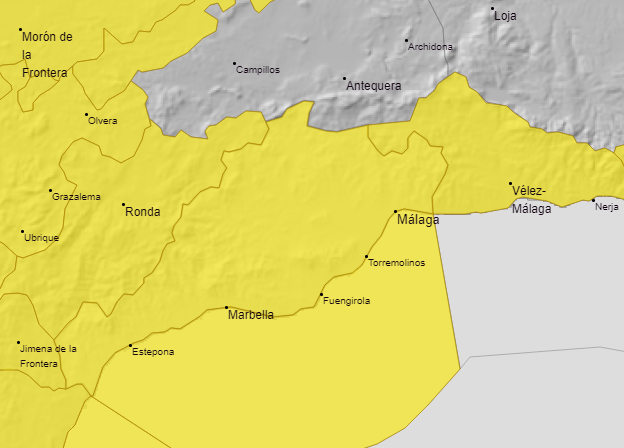
After Saturday and Sunday's downpours, Malaga province is facing another day of heavy rainfall with a yellow warning. Spain's state meteorological agency (Aemet) is maintaining the weather warnings active for accumulated rainfall of 15mm in one hour and up to 40mm in 12 hours. The warning, which includes thunderstorms, affects Malaga city, the Costa del Sol, Guadalhorce valley, Axarquia and Serranía de Ronda throughout the day.
The storm that is affecting the majority of Malaga province has a name: Jana. And it has been christened (not all of them are) because it has been classified as "high impact", that is, it has potential consequences for the population that are greater than normal. This is how the director of the Aemet meteorological centre, Jesús Riesco, explained it: "Jana is a deep low that will bring an intense humid flow and will leave significant rainfall and accumulations".
The heavy rains will continue this Monday (10 March). So much so that Aemet has activated warnings for heavy rain until tomorrow. On Tuesday, the warning will be for coastal phenomena: winds from the west and southwest of 50 to 60 km/h (force 7) and waves of 2 to 3 metres are expected.
"They are not going to be very intense, but the most characteristic feature of this type of situation is the persistence, it is going to rain for several hours at a time," warned Jesús Riesco, who graphically describes "the passage of one band after another". The problem, as the meteorologist pointed out, is that there has already been some local flooding, in parts of the upper Guadalhorce and Ronda, so we will have to keep an eye on the levels of the rivers.
This week
Rain will continue to fall for most of the week and will continue to fall on saturated ground "More storms are going to reach the Spanish mainland, so they will continue". In general, the rainfall will not be very heavy but it will continue. In theory, the only day that will give some respite will be Tuesday, due to the transition between one mass and the next.
The Aemet weather models are already warning of the possibility of a train of fronts that will gently but generally spread over the province until at least Friday.
March is getting rainier and rainier
It is clear that what was predicted years ago by various studies carried out by the Malaga meteorological mentre is coming true, since it has been observed that a change is taking place in the traditional pattern of the distribution of rainy seasons in the province, which until recently was considered "normal". As a result, the most abundant episodes of rain are shifting from autumn (September to November) to spring (February-April, and especially in March). This situation is being observed year after year.
Until a decade ago, the "jackpots" of the hydrological year were usually November and December, traditionally the wettest months, with an average of 100mm (measured at Malaga Airport). These two are decreasing in rainfall, but March is now the third wettest month of the year (with an average of 65mm), having overtaken January and February.