Weather
Aemet upgrades weather alert to amber risk level for heavy rain and thunderstorms in Malaga province tomorrow
As the Atlantic storm rolls into the western Costa del Sol and Ronda areas tonight, forecasters predict that up to 80mm of rain could fall throughout the day on Saturday in some points

Málaga
Spain's state weather agency has raised the warning for heavy rainfall in Malaga province for tomorrow, Saturday. Specifically, the amber level (moderate risk) has been activated for Ronda and the Serrania, due to the possibility of up to 80mm in twelve hours.
The head of Aemet, Jesús Riesco, said it is due to the "flow of westerly winds". In fact, there is also an active warning (yellow level) for maximum gusts of 70 km/h from the south, first, turning west in the course of the day. Similarly, there may be occasional showers of up to 25 mm in an hour.
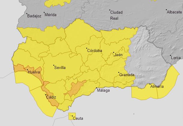
In addition, the map of Malaga province offers an unusual picture, completely painted with yellow (except for the amber area in Ronda) in the Aemet forecasts. It is more common for either the western or eastern areas to be under weather alerts, but it's rare for them to be affected at the same time. This is the scenario that the weather centre is forecasting for this Saturday, when all the municipalities of Malaga will be under a heavy rain warning.
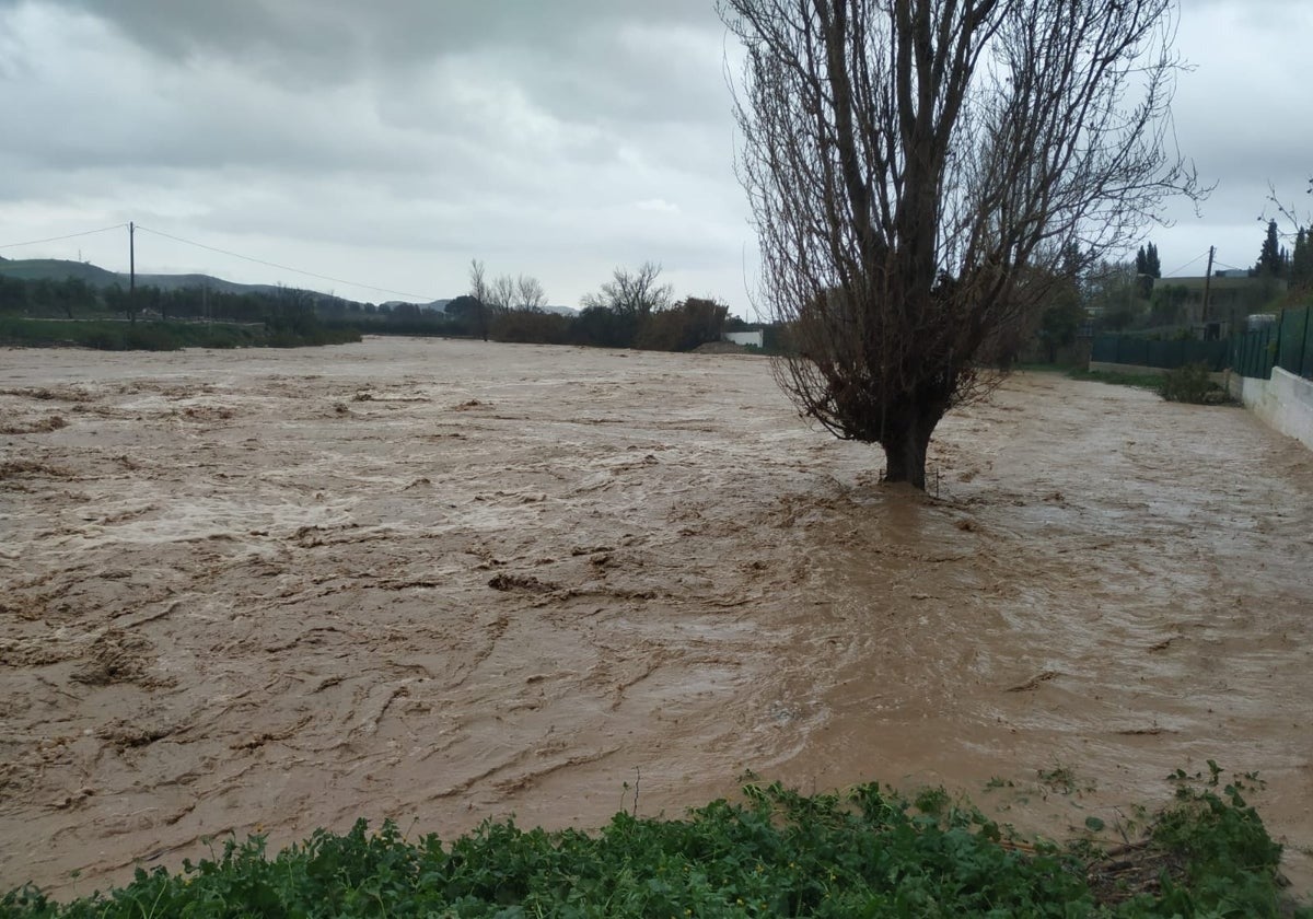
Specifically, Aemet predicts rainfall from midnight this Friday evening until 9pm on Saturday. In general terms, this could leave accumulated rainfall of 60mm over the course of the day, and 20mm in one hour. "The rainfall will be accompanied by thunderstorms," warns the forecast. Although the level of risk is generally low, the problem is that it is going to return to discharge with intensity in areas where the watercourses are already heavily laden with water from this week's 'Dana', especially in the upper Guadalhorce valley and the Serranía de Ronda. .
More rain next week
The rains will not only give a good soaking this weekend in Malaga, but will continue throughout most of next week. The first band of precipitation from a deep Atlantic storm will begin to affect the province in the area of the western Costa del Sol and Ronda from late this Friday, according to the director of the Aemet, Jesús Riesco. "The high impact storm Jana is a deep low that will bring an intense wet flow over the next few days, up to and including Monday, and will leave significant rainfall and accumulations". The heaviest rainfall will be tomorrow, although it will continue to a lesser extent on Sunday.
The accumulated rainfall in Malaga province is expected to be abundant and widespread, so for the moment Aemet is maintaining a yellow warning tomorrow in all the areas (except Ronda where it will be amber), both for accumulated rainfall of 20mm in one hour and 60mm in 12 hours.
"They are not going to be very intense, but the most characteristic feature of this type of situation is the persistence, it is going to rain for quite a few hours". Jesús Riesco graphically described the passage of one band after another. The problem, warns the meteorologist, is that there has already been some local flooding, in parts of the upper Guadalhorce valley and Ronda, so we will have to keep an eye on the rise of the rivers.
This situation will last until Monday, but then next week also sees showers, so it will continue to rain on the wet ground. "More storms are going to arrive on the Spanish mainland, so they will continue". The rainfall will generally not be very heavy but it will continue.
The Aemet weather models are already warning of the possibility of a train of fronts that will generally, although gently, spread across the province until at least Thursday of next week.
March is getting wetter and wetter
It is clear that what was predicted years ago by various studies carried out by the Malaga meteorological centre is coming true, since it has been observed that a change is taking place in the traditional pattern of the distribution of rainy seasons in the province, which until recently was considered "normal". As a result, the most abundant episodes are shifting from autumn (September to November) to spring (February-April, and especially in March). This situation is being observed year after year.
Until a decade ago, the "big prizes" of the hydrological year were usually November and December, traditionally the wettest months, with an average of 100mm (measured at Malaga Airport). These two are decreasing in rainfall, but March is now the third wettest month of the year (with an average of 65mm), having overtaken January and February.