112 Andalucía
Ronda underground floods and tremors prompt rethinking of rural safety in Andalucía
Scientists and emergency officials say extreme rainfall exposed hidden dangers in karst aquifers, prompting new monitoring and emergency measures
Chus Heredia
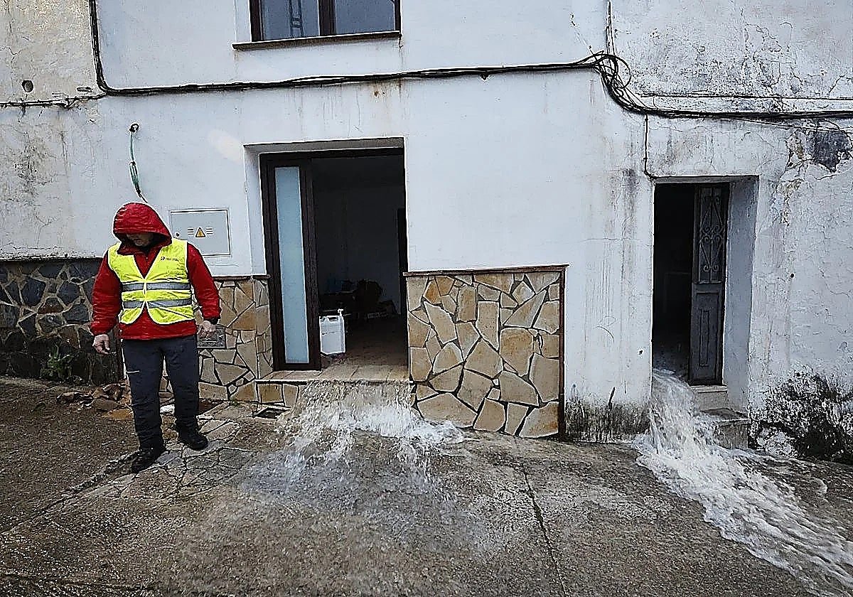
The Serranía de Ronda experienced a historic storm in the first week of February 2026. Storm Leonardo brought up to 150mm in less than 12 hours. The Aemet state meteorological agency issued a red weather and the authorities carried out the precautionary evacuations of residents of several villages.
The ground's capacity to absorb water was put to the test after an exceptionally wet winter, so much so that the Montejaque reservoir filled for the first time in its century-long history, despite the permeability of the terrain.
The large aquifer of the Sierra de Líbar has been extensively studied and has formed the subject of numerous academic papers and theses. A recent study shows that most drainage in this karst system flows through the Hundidero-Gato complex and downstream of the aforementioned reservoir (the springs of the Cueva del Gato and Benaoján, Jimera de Líbar and the Charco del Moro, which emerge directly into the Guadiaro river).
Related story
-RAFCSVIxxMDPyx7fGttheLJ-1200x840Diario%20Sur_20260615100846-RuwQGUp3SKCFkQtmEA4cobL-366x256@Diario%20Sur.jpg)
That interaction between groundwater and river systems (including the reservoir) is key to understanding the flooding, in a phenomenon similar to what happened in Grazalema.
Turning point
Everything that happened marked a turning point in flood risk management in Andalucía. The storms, which forced the full evacuation of Grazalema and partial evacuations in Benaoján, Jimera de Líbar, Cortes de la Frontera and parts of Ronda, have led authorities to include karst aquifers in overall flood risk planning.
Scientists, technicians and politicians are now drawing conclusions after an emergency involving underground flooding, "earthquake swarms" and rumblings from beneath the ground.
These events were discussed at a conference chaired by SUR, featuring Juan Andrés Olalla (technical adviser for emergencies and civil protection for the Andalusian regional government), Policarp Garay (president of the Spanish society of speleology and karst science), Javier Pérez (First Deputy Mayor of Grazalema) and Sergio Martos (hydrogeology coordinator at GADE-CSIC during the emergency).
Piezometric monitoring
Martos confirmed that monitoring sensors have been installed in control wells and that the Andalusian regional government has repaired the gauging station at the Cueva del Gato spring. "In Grazalema, we need to drill control wells or piezometers fitted with water-level sensors to establish early warning systems for hydrogeological flooding," he said.
These devices measure the level of groundwater and its pressure underground. These floods can be caused by a rise in water level or by the discharge of more water than normal through natural outlets.
Pérez addressed the aftermath of the February emergency in Grazalema. "The municipality is almost at 95 per cent recovery, but residents are still living in fear," he said. He added that the town is usually one of the safest in Spain due to extensive geological and hydrological studies.
During the emergency, the town hall activated level 1 of its response plan in highly unusual circumstances, as water began emerging through walls. When the situation escalated to level 2, authorities closed roads, preventing additional emergency teams from entering the area.
"Fortunately, we already had around 250 personnel on the ground from the military emergency unit, civil protection and the Red Cross, all working in a coordinated response," Pérez said, adding that much of the fear among residents came from not understanding what was happening and from underground noises.
Uncertainty
Uncertainty over what was happening underground was also evident at the emergency command centre. From the Ronda control post, Juan Andrés Olalla said the main concern did not focus on surface flooding but on underground processes and the seismic swarms.
The Montejaque dam caused the greatest concern. The abandoned structure has no emergency plan and authorities could not tell whether its spillways would work. With the earthquakes, this became the main focus of attention.
Olalla stressed that planners must include karst aquifer risk in overall flood-risk strategies and said the regional emergency directorate is developing an operational response plan.
Communication
Martos said science offers the best way to manage emergencies. "The CSIC and IGME brought together mayors and technical staff to share findings and tackle rumours circulating in the media," he explained.
After the crisis, CSIC published several reports and funded two research projects: one on hydrology and hydroseismicity led by Martos and another on ground movement.
"We are trying to get the regional government to install piezometers in Grazalema," he said. "At the time, people feared water levels might rise above ground level, affecting foundations and potentially causing structural collapse."
Once levels fell and engineers confirmed the water network had not suffered damage, teams used ground-penetrating radar at different frequencies and found cavities very close to the surface in courtyards and main streets. Geophysics then helped residents return home safely.
"It's not a river. It's a volume of water that flows in and out wherever it can. When an aquifer becomes fully charged, old drainage channels reactivate and permeability increases over time, so we need to keep recharge and drainage areas clear," Garay said.
Urban planning in Grazalema made the situation worse and will play a key role in future prevention. Martos and Pérez explained that tarmac surfaces blocked the old chambers that once drained water into the street. Pérez confirmed that water emerged in straight lines through walls, following an old natural channel known as "la madre".
The town hall now plans to change planning rules to require ground surveys for new buildings.
A similar situation occurred in Benaoján, within a different aquifer, under the same rainfall conditions. Previous studies and doctoral research had already examined the behaviour of the Líbar system and earlier episodes of the Montejaque reservoir filling, showing rising water levels and overflow towards Grazalema.
"We are fortunate because permeability and infiltration are high and the ground can drain water efficiently, but this will happen again in more places, which shows why we need to include geology in education," Martos concluded.
Storm Leonardo 2026 in pictures