Sections
Highlight
FRANCISCO GUTIÉRREZ
Tuesday, 13 October 2020, 15:54
Compartir
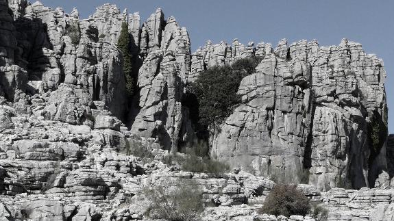
El Torcal in Antequera is one of the symbols of Malaga province. The strangely shaped rock formations in this area of the countryside never go unnoticed, and over the years it has become a major tourist attraction. In fact, together with the Nerja Cave, it is the most important geological formation in Malaga province, says geologist José Manuel García Aguilar, who has included this and other natural enclaves in his book 'Patrimonio geológico de la provincia de Málaga', the second edition of which has just been published by the University of Malaga.
El Torcal de Antequera is considered one of the most important karst landscapes in Europe and is Malaga's principal natural wonder. It was declared a Site of Natural Interest as long ago as 1929, and was the first protected area in Andalucía to receive national classification. In 1978 it became an official nature reserve, and in 1989 obtained the category of 'paraje natural', an area of outstanding beauty. In 2014 it received additional protection as a Special Conservation Area.
El Torcal is located in a mountainous area, facing east-west, with a length of approximately 11 kilometres and a maximum height of 1,377 metres at the Camorro Alto peak. The landscape has been configured over thousands of years through erosion of the limestone rocks.
The stacked layers of these rocks, like piles of 'biscuits', are very typical and some formations have been given nicknames due to their appearance: 'El Tornillo' (The Screw), which itself is classified as a natural monument, 'La Catedral' (The Cathedral) and 'El Sombrero' (The Hat).
There are also numerous fossils in these rocks, such as ammonites and belemnites, pelagic marine animals which were common during the Jurassic period, explains José Manuel, who is a biology and geology teacher at Los Boliches secondary school in Fuengirola and also works with Malaga university.
Los Riscos de Cartajima
However, Antequera is not the only place in Malaga province to have interesting 'Torcals', as José Manuel explains in his book. To the north of Cartajima there are others, known as the 'Riscos de Cartajima'. These cover an area of 22.2 square kilometres and comprise grey limestone rocks which are similar to those of El Torcal, although in this case the rocks are mainly from the early and middle Jurassic period. They contain remains of fossilised algae, indicating a marine origin and are either horizontal or inclined in 'screw' shapes.
The steep internal edges create a sequence of eye-catching, almost vertical cliffs reaching heights of between 15 and 35 metres with ridgelines that seem to have been cut in the form of oddly-shaped towers. It makes a unique image, and one which is very different from those we see in other areas of this type in the province, says José Manuel.
Sierra de Utrera
About two kilometres from Manilva is the 'Torcal' of the Sierra de Utrera. This is another notable example, says José Manuel García, because it is oval in shape and faces north-south, with lengths of 2.3 and 1.2 kilometres, a surface area of 4.4 square kilometres and an average height of around 300 metres above sea level.
The differences in height create a rocky promontory about 200 metres high, in the form of an isolated mountain.
This area has also developed an aquifer which is linked to a thermal spring at the Baños de la Hediaonda, where the sulphuric waters maintain a temperature of about 22 to 23 degrees Celsius.
Peñón del Berrueco
Another area of rock formations which José Manuel says is of interest is the 'Torcal' of Peñón del Berrueco, which is in Cortes de la Frontera, on the border with Cadiz province.
This one is considered an outstanding site of geological interest because of its karst phenomena and exceptional isolated mountain morphology. It is about 120 metres high, with a circular ground area which is 550 metres in diameter and an average height of 850 metres above sea level.
This same municipality is also home to another, the 'Torcal' of Motillas, which covers an area of 0.72 square kilometres, has a perimeter of five kilometres and an average height of 500 metres above sea level. It consists of Jurassic limestone rocks.
The karst shapes here are very beautiful, dominated by horizontal cavities and over six kilometres of galleries, such as the Cueva del Agua (Water Cave), landforms of different heights, corridors and strata stacked in unusual shapes, explains José Manuel.
The wealth of karst rock in Malaga province is also reflected by the presence of other 'Torcals', most of which have barely been explored from a geological point of view, he says.
One particularly important area has been found in the Sierra de las Nieves, where there are two areas of grey limestone and dolomites from the late Triassic-early Jurassic period in the areas known as El Navazuelo and El Puerto de los Pilones. The second of these is large, about 6.4 square kilometres in size, and is at the heart of the Natural Park, beside the track up to the Torrecilla peak.
There are also extensive 'Torcals' in the higher parts of the Sierra de los Merinos and Sierra Llana, between Ronda and El Chorro. In addition, there are Jurassic calcareous reliefs to the north of Atajate, situated at a considerable height, which indicates an intense network of tectonic fractures, says José Manuel.
Finally, there is the 'Torcal' to the north of Los Tajos de Alfanatejo, which covers an area of 2.6 km2. The access to this area is signposted on the MA-4103, south of Alfarnatejo, and a hiking route leads up to it.
Publicidad
Publicidad
Publicidad
Publicidad
Reporta un error en esta noticia
Necesitas ser suscriptor para poder votar.